Clever Me Part 2

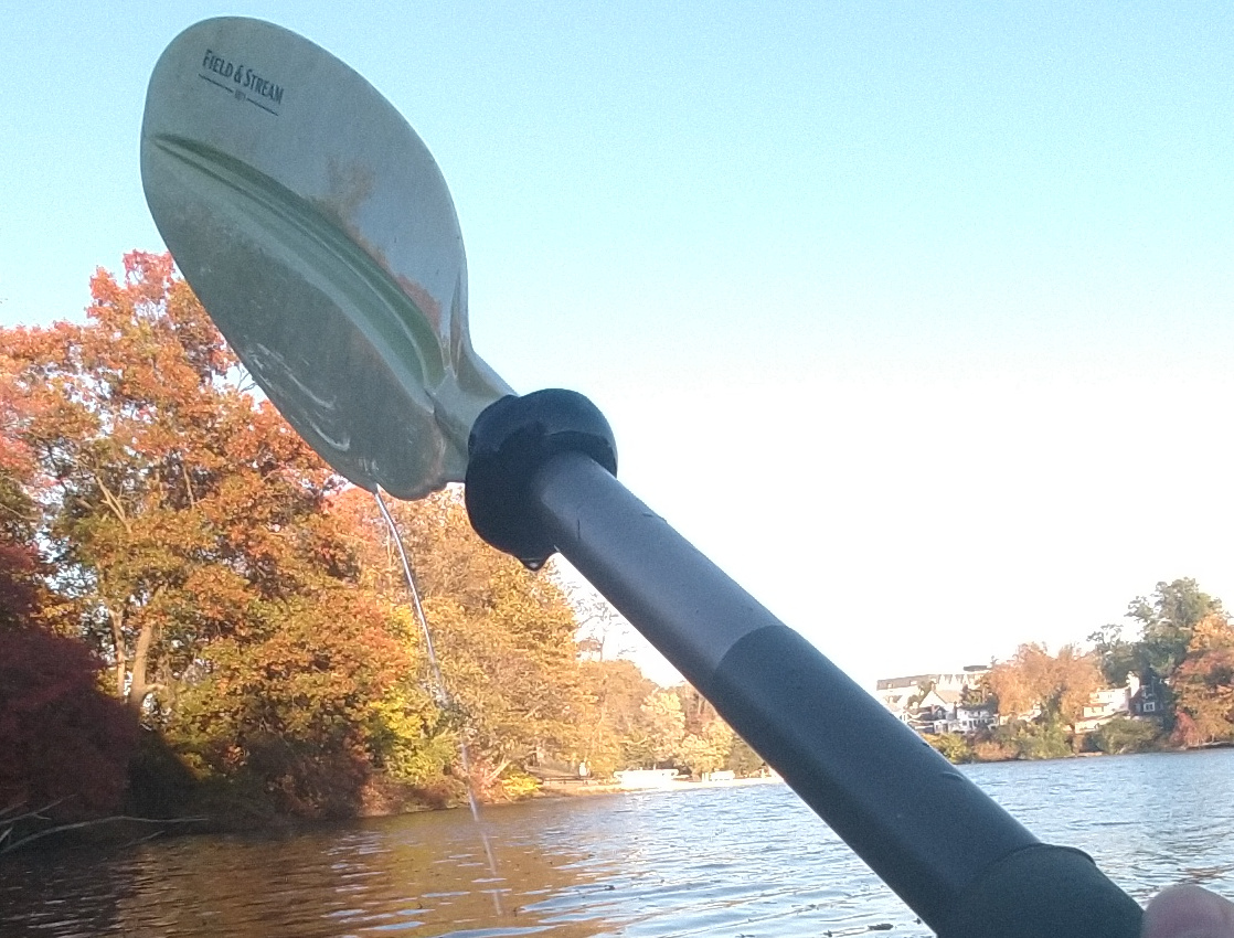
This paddle is nearing the end of its life, so I decided to try an experiment. I added a "drip notch". This is a small sharp-edged notch that the water flow can't follow. Instead it departs the edge of the paddle and falls well outside the boat. I hardly got a drop of water on me.

To make the notch, simply drill a 1/4" hole by the edge of the plastic blade, 6-7 inches from the base. Then file it to the shape you see here, with a sharp corner at the edge. The back-cut assures the the stream can't jump over the notch to the other side.

I can't claim this idea, I've seen a few paddles with this feature.


Sussex County
( 41.13351, -74.73848 )

  1. Budd Lake - Hackettstown ( 40.86292, -74.75154 )
  2. Clinton Reservoir (N) ( 41.09734, -74.44232 )
  3. Clinton Reservoir (S) ( 41.09409, -74.44102 )
  4. Cranberry Lake - Andover ( 40.95204, -74.73681 )
  5. Delaware River - Caddo Access ( 41.31834, -74.79522 )
  6. Delaware River - Dingman's Ferry PA ( 41.21942, -74.86017 )
  7. Delaware River - Port Jervis NY ( 41.37715, -74.70473 )
  8. Delaware River - Poxono ( 41.04019, -75.02293 )
  9. Delaware River - Rockcores Trailhead ( 41.01750, -75.07020 )
  10. Delaware River - Turtle Beach ( 41.03352, -75.03776 )
  11. Lake Aeroflex - Andover ( 41.01041, -74.73564 )
  12. Lake Hopatcong - Ashley's Cove ( 40.96426, -74.61082 )
  13. Lake Hopatcong - Hopatcong (E) ( 40.92890, -74.63861 )
  14. Lake Hopatcong - Hopatcong (W) ( 40.91763, -74.66346 )
  15. Lake Musconetcong - Netcong ( 40.90099, -74.70354 )
  16. Lake Musconetcong - Port Morris Park ( 40.90851, -74.68505 )
  17. Lamington/Black River - Route 10 ( 40.86048, -74.62893 )
  18. Morris Canal - Waterloo ( 40.91259, -74.76785 )
  19. Musconetcong River - Saxton ( 40.88829, -74.79732 )
  20. Musconetcong River - Stephens SP ( 40.87225, -74.80619 )
  21. Musconetcong River - Waterloo (N) ( 40.91147, -74.76912 )
  22. Musconetcong River - Waterloo (S) ( 40.89663, -74.79111 )
  23. Neversink River - Port Jervis NY ( 41.37589, -74.67546 )
  24. Paulins Kill - access ( 41.07478, -74.78607 )
  25. Paulins Kill - Blairstown ( 40.97758, -74.94390 )
  26. Paulins Kill - Footbridge Park ( 40.98121, -74.95964 )
  27. Paulins Kill - Stillwater ( 41.03284, -74.87420 )
  28. Paulins Kill Lake - Newton ( 41.05273, -74.82674 )
  29. Peaquannock River - Oak Ridge Reservoir ( 41.06314, -74.48597 )
  30. Pequest River - Allamuchy ( 40.92160, -74.84089 )
  31. Rockaway River - Rockaway (E) ( 40.90190, -74.50881 )
  32. Rockaway River - Wharton ( 40.88947, -74.56952 )
  33. Rockaway River - WMA ( 40.95537, -74.57069 )
  34. Silver Lake - Hope ( 40.93370, -74.94996 )
  35. Split Rock Reservoir - Rockaway ( 40.96274, -74.45808 )
  36. Steeny Kill Lake - High Point ( 41.32085, -74.67720 )
  37. Sunset Lake ( 40.87071, -74.61751 )
  38. Swartswood Lake - Newton (N) ( 41.07356, -74.82440 )
  39. Swartswood Lake - Newton (S) ( 41.06296, -74.85278 )
  40. Tilcon Lake - Waterloo ( 40.90717, -74.76840 )
  41. Walkill River - Bassetts Bridge ( 41.26008, -74.55100 )
  42. Walkill River - Franklin ( 41.11063, -74.58840 )
  43. Walkill River - Glenwood Rd ( 41.19413, -74.57499 )
  44. Walkill River - Hamburg ( 41.15266, -74.58161 )
  45. Walkill River - Unionville NY ( 41.28789, -74.53406 )
  46. Wawayanda Lake - Wawayanda SP ( 41.18823, -74.42609 )
  47. White Lake - Freylinghausen ( 41.00076, -74.91654 )

Printed from njkayak.net