Liberty State Park - Jersey City


  1. Liberty State Park - Jersey City [G] [B] (40.69768, -74.06520)

(0)

Parking and launch access are free. There can be a good deal of boat traffic on the river, especially ferries, but if you are careful, you can paddle around the Statue of Liberty and Ellis Island. The museum in the old railroad/ferry terminal is another point of interest.

Both islands have landings, but I wouldn't try to use them! I also don't think you'd be very welcome if you went in the marina to the north, but apparently paddling the river is ok. The marina is the outlet of the long-gone Morris Canal. Just a few small bits of the canal still hold water in Sussex County.

Finally, remember you are in the Hudson River, and may end up dealing with a strong current, especially if the tide is out-going.
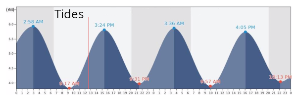
Tides
[Google] [Bing] [Reset Map] ( 40.69506, -74.05267 )

Comments on Liberty State Park - Jersey City

Questions or Inquiries?

Just want to say Hello? Sign the .

Submit a Comment

Your email address will not be published. Required fields are marked *


Click image to replace if unable to read.

Enter the digits from the image above, except for the last one:

This site uses Akismet to reduce spam. Learn how your comment data is processed.


  1. Barnegat Bay - Barnegat [Details] [G] [B] (39.75442, -74.19095)
  2. Barnegat Bay - Barnegat Light (N) [Details] [G] [B] (39.75763, -74.11138)
  3. Barnegat Bay - Barnegat Light (S) [Details] [G] [B] (39.74500, -74.11764)
  4. Barnegat Bay - Bay Harbor Park [Details] [G] [B] (40.01977, -74.12731)
  5. Barnegat Bay - Brant Beach [Details] [G] [B] (39.61673, -74.20110)
  6. Barnegat Bay - Bridge to Nowhere [Details] [G] [B] (39.68394, -74.20766)
  7. Barnegat Bay - Harvey Cedars [Details] [G] [B] (39.70465, -74.13703)
  8. Barnegat Bay - Island Beach SP [Details] [G] [B] (39.85222, -74.08899)
  9. Barnegat Bay - Lavallette [Details] [G] [B] (39.96933, -74.07421)
  10. Barnegat Bay - Mantoloking Bridge [Details] [G] [B] (40.04124, -74.05880)
  11. Barnegat Bay - Oyster Creek [Details] [G] [B] (39.80873, -74.18455)
  12. Barnegat Bay - Parkertown [Details] [G] [B] (39.60978, -74.29231)
  13. Barnegat Bay - Seaside Heights [Details] [G] [B] (39.94524, -74.07956)
  14. Barnegat Bay - Sedge Island [Details] [G] [B] (39.80786, -74.09599)
  15. Barnegat Bay - Ship Bottom [Details] [G] [B] (39.65232, -74.18484)
  16. Barnegat Bay - Tilton Point [Details] [G] [B] (39.96900, -74.11284)
  17. Barnegat Bay - Tuckerton [Details] [G] [B] (39.57671, -74.33078)
  18. Barnegat Bay - West Creek [Details] [G] [B] (39.63100, -74.29618)
  19. Barnegat Bay - Woodville [Details] [G] [B] (39.98917, -74.13476)

(1)

Printed from njkayak.net