Liberty State Park - Jersey City

Liberty State Park
( 40.70139, -74.05094 )

Parking and launch access are free. There can be a good deal of boat traffic on the river, especially ferries, but if you are careful, you can paddle around the Statue of Liberty and Ellis Island. The museum in the old railroad/ferry terminal is another point of interest.

Both islands have landings, but I wouldn't try to use them! The marina is the outlet of the long-gone Morris Canal. Just a few small bits of the canal still hold water in Sussex County. Finally, remember you are in the Hudson River, and may end up dealing with a strong current, especially if the tide is out-going.
The star attraction
( 40.68925, -74.04453 )

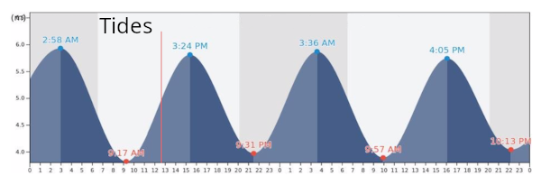
Tides

Comments on Liberty State Park - Jersey City

Questions or Inquiries?

Just want to say Hello? Sign the .

Submit a Comment

Your email address will not be published. Required fields are marked *


Click image to replace if unable to read.

Enter the digits from the image above, except for the last one:

This site uses Akismet to reduce spam. Learn how your comment data is processed.


Raritan River
( 40.59399, -74.59918 )

  1. Raritan River - Bound Brook ( 40.55995, -74.52758 )
  2. Raritan River - Branchburg ( 40.55644, -74.68838 )
  3. Raritan River - Duke Island (E) ( 40.56082, -74.64751 )
  4. Raritan River - Duke Island (W) ( 40.55279, -74.68330 )
  5. Raritan River - Edison ( 40.48791, -74.38382 )
  6. Raritan River - Highland Park ( 40.48864, -74.42226 )
  7. Raritan River - New Brunswick ( 40.48760, -74.43280 )
  8. Raritan River - Perth Amboy ( 40.50057, -74.27712 )
  9. Raritan River - Piscataway (N) ( 40.54085, -74.51236 )
  10. Raritan River - Piscataway (S) ( 40.50935, -74.46641 )
  11. Raritan River - Power Canal ( 40.55112, -74.67136 )
  12. Raritan River - Raritan ( 40.56492, -74.63884 )
  13. Raritan River - Sayreville ( 40.47450, -74.35606 )
  14. Raritan River - Somerville (E) ( 40.55798, -74.61520 )
  15. Raritan River - Somerville (W) ( 40.56539, -74.63173 )
  16. Raritan River North Branch ( 40.60018, -74.67447 )
  17. Raritan River North Branch - Far Hills ( 40.68441, -74.64214 )
  18. Raritan River North Branch - Natirar Park ( 40.64761, -74.68024 )
  19. Raritan River North Branch Depot ( 40.58160, -74.68161 )
  20. Raritan River South Branch ( 40.54640, -74.69603 )
  21. Raritan River South Branch - Clinton (N) ( 40.63854, -74.91169 )
  22. Raritan River South Branch - Clinton (S) ( 40.62806, -74.91200 )
  23. Raritan River South Branch - Flemington (C) ( 40.52105, -74.82666 )
  24. Raritan River South Branch - Flemington (E) ( 40.50354, -74.77814 )
  25. Raritan River South Branch - Flemington (N) ( 40.53810, -74.83934 )
  26. Raritan River South Branch - Hamden ( 40.59699, -74.89827 )
  27. Raritan River South Branch - High Bridge (N) ( 40.66394, -74.89742 )
  28. Raritan River South Branch - High Bridge (S) ( 40.66094, -74.90237 )
  29. Raritan River South Branch - Lockwood Gorge (N) ( 40.69682, -74.87171 )
  30. Raritan River South Branch - Lockwood Gorge (S) ( 40.68816, -74.88014 )
  31. Raritan River South Branch - Neshanic (E) ( 40.50873, -74.72776 )
  32. Raritan River South Branch - Neshanic (W) ( 40.50250, -74.74182 )
  33. Raritan River South Branch - Rte 31 ( 40.56315, -74.85544 )
  34. Raritan River South Branch - Stanton ( 40.57219, -74.86834 )
  35. Raritan River South Branch - Sunnyside ( 40.57942, -74.88795 )

The Raritan River is what is left of the outflow of the Hudson River after it broke through the Verrazano Narrows about 6,000 years ago and changed to its present course. The modern Raritan River drains much of central New Jersey, with tributaries threading through the state from Princeton to Morristown. One northern tributary - the Lamington River - reaches almost to Lake Hopatcong. Zoom the map out to see the entire drainage. The thin red line is the "fall line" - the nominal division between uplands and lowlands.

Printed from njkayak.net