Prospertown Lake WMA - Jackson

Prospertown Lake - Jackson
( 40.13370, -74.44958 )

  1. Prospertown Lake - Jackson ( 40.13497, -74.45779 )

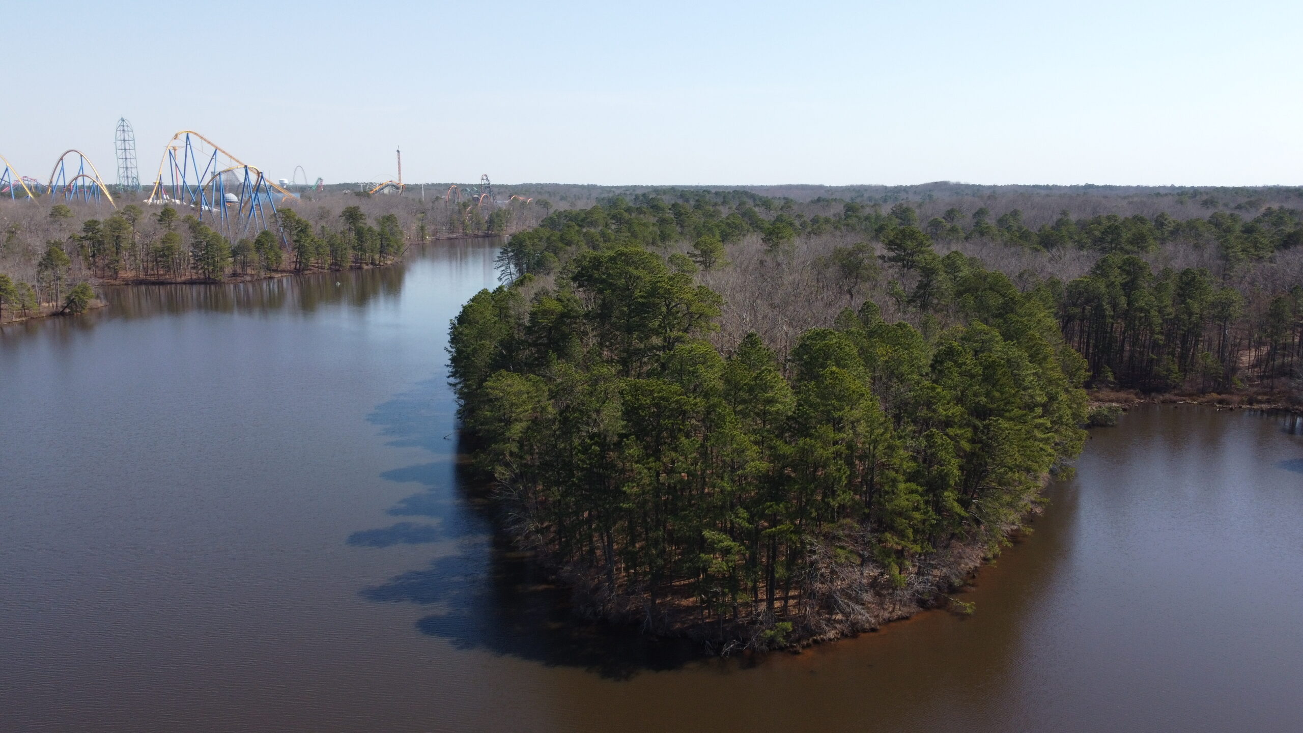
This is a nice clean lake that straddles the border between Monmouth and Ocean Counties. The neat thing about it is, if you scroll the map to the upper-right corner, that is not some industrial park, that is Great Adventure! This is the lake that is at the back of the park. At the east end of the lake, you are looking up at all the rides, while to the south is the Safari Park. You can see more water from there, but I wouldn't jump any of the dykes, as that would put you on Great Adventure's property, or maybe in the lion pen. It's not a big lake, but there is plenty of shoreline to inspect. There is a small dam at the western end. No real facilities, just parking.

Prospertown Lake is not a park, it is a "Wildlife Management Area", and falls under a completely different set of regulations, which you can find here:

  • https://dep.nj.gov/njfw/wildlife/wildlife-management-area-regulations

From the state website:

Any vehicle used to transport or launch a vessel or water conveyance on the following WMAs must have affixed to the lower corner of the driver’s side rear window a Boat Ramp Maintenance Permit or a photocopy of a current hunting, fishing or trapping license showing the Conservation ID Number (CID#). Identifying information other than the CID# may be blacked out to protect your identity. Boat Ramp Maintenance Permits may be purchased for a fee of $15.00 from any license agent or Fish and Wildlife’s license Web site (under “Wildlife Management Area Use Permits” after logging in and selecting to make a purchase).


Comments on Prospertown Lake WMA

Questions or Inquiries?

Just want to say Hello? Sign the .

Submit a Comment

Your email address will not be published. Required fields are marked *


Click image to replace if unable to read.

Enter the digits from the image above, except for the last one:

This site uses Akismet to reduce spam. Learn how your comment data is processed.


Gloucester County
( 39.69751, -75.18109 )

  1. Alcyon Lake ( 39.72831, -75.14290 )
  2. Alloway Creek - Hancock's Bridge ( 39.50763, -75.46339 )
  3. Alloway Lake - Alloway ( 39.56288, -75.36070 )
  4. Atsion Lake - Pinelands ( 39.73989, -74.73128 )
  5. Avis Millpond - Salem River ( 39.63089, -75.29061 )
  6. Big Timber Creek - Fort Nassau ( 39.88024, -75.12680 )
  7. Big Timber Creek - Glendora (N) ( 39.85285, -75.09452 )
  8. Big Timber Creek - Glendora (S) ( 39.83769, -75.08264 )
  9. Blackwood Lake - Big Timber Creek ( 39.80194, -75.07405 )
  10. Bostwick Lake - Cohansey River ( 39.52842, -75.26801 )
  11. Cedar Creek - Stow Creek ( 39.44393, -75.40885 )
  12. Cohansey River - Bridgeton ( 39.42658, -75.23626 )
  13. Cohansey River - Dix WMA ( 39.37361, -75.29350 )
  14. Cohansey River - Ragged Island St. ( 39.36792, -75.35818 )
  15. Cooper River - Haddonfield ( 39.90090, -75.02056 )
  16. Cooper River Lake - Collingswood ( 39.92432, -75.07123 )
  17. Cooper River Park - Haddonfield ( 39.92561, -75.05672 )
  18. Delaware River - Barnegat Lightship ( 39.95725, -75.11244 )
  19. Delaware River - Carney's Point ( 39.71737, -75.47630 )
  20. Delaware River - Elsinboro Point ( 39.54510, -75.52995 )
  21. Delaware River - Fort Mott ( 39.60585, -75.55596 )
  22. Delaware River - Mad Horse ( 39.42123, -75.42695 )
  23. Delaware River - Miller Road ( 39.38263, -75.40641 )
  24. Delaware River - North Camden ( 39.95769, -75.11432 )
  25. Delaware River - Palmyra Cove ( 40.00916, -75.04176 )
  26. Delaware River - Paulsboro ( 39.84785, -75.25124 )
  27. Delaware River - Pennsauken ( 39.98092, -75.06567 )
  28. Delaware River - Pennsville ( 39.64836, -75.53254 )
  29. Delaware River - Rivergate ( 39.87718, -75.17961 )
  30. Delaware River - West Deptford ( 39.86198, -75.20709 )
  31. DOD Ramp - Penns Grove ( 39.74873, -75.45564 )
  32. Dramasel/Pines Lake ( 39.81713, -75.04735 )
  33. East Lake - Salem River ( 39.64274, -75.31400 )
  34. Franklinville Lake - Franklinville ( 39.61768, -75.07867 )
  35. Great Egg Harbor River - New Brooklyn ( 39.70187, -74.93732 )
  36. Great Egg Harbor River - Penny Pot ( 39.57547, -74.82239 )
  37. Great Egg Harbor River - Piney Hollow Rd ( 39.62049, -74.89280 )
  38. Great Egg Harbor River - Weymouth ( 39.51339, -74.77889 )
  39. Hammonton Lake ( 39.63010, -74.78734 )
  40. Hester's Branch - Woodbury ( 39.83155, -75.14812 )
  41. Indian Mills Lake ( 39.79554, -74.73998 )
  42. Kirkwood Lake - Cooper River ( 39.83637, -75.00105 )
  43. Laurel Lake ( 39.81720, -75.01032 )
  44. Malaga Lake - Newfield ( 39.57878, -75.05643 )
  45. Mantua Creek - West Deptford ( 39.79546, -75.17112 )
  46. Maurice River - Alliance Beach ( 39.50198, -75.07976 )
  47. Maurice River - Garden Road ( 39.52199, -75.07329 )
  48. Maurice River - Milleville ( 39.37706, -75.03671 )
  49. Maurice River - Sharp St ( 39.40012, -75.05345 )
  50. Maurice River - West Side Park ( 39.49608, -75.07611 )
  51. Maurice River - Willow Grove ( 39.54996, -75.07146 )
  52. Newton Creek - Johnson Park ( 39.89464, -75.11321 )
  53. Newton Lake - Collingswood ( 39.90840, -75.08179 )
  54. Oldman's Creek - Bridgeport ( 39.78437, -75.40694 )
  55. Oldman's Creek - Harrisonville ( 39.68277, -75.26706 )
  56. Oldman's Creek - Swedesboro ( 39.74857, -75.37972 )
  57. Parvin Lake - Pittsgrove ( 39.50613, -75.12979 )
  58. Pennsauken Creek - Cinnaminson (E) ( 39.97961, -75.00867 )
  59. Pennsauken Creek - Cinnaminson (W) ( 39.98056, -75.01119 )
  60. Raccoon Creek - Bridgeport ( 39.80121, -75.35517 )
  61. Raccoon Creek - Mullica Hill ( 39.73444, -75.22043 )
  62. Rainbow Lake - Pittsgrove ( 39.48757, -75.11186 )
  63. Rancocas Creek - Medford Park ( 39.89713, -74.82061 )
  64. Repaupo Creek - Logan Twp ( 39.82960, -75.33016 )
  65. Salem River - Mannington ( 39.66957, -75.46619 )
  66. Salem River - Salem ( 39.57881, -75.46628 )
  67. Salem River - Supawna NWR ( 39.56956, -75.49853 )
  68. Salem River - Woodstown ( 39.64486, -75.32774 )
  69. Salem River WMA - Pennsville ( 39.64026, -75.48012 )
  70. Stewart Lake - Woodbury ( 39.84193, -75.14283 )
  71. Strawberry Lake - Moorestown ( 39.95460, -74.94940 )
  72. Sunset Lake - Cohansey River ( 39.44637, -75.23975 )
  73. Thundergust Lake ( 39.50277, -75.13396 )
  74. Timber Creek ( 39.83638, -75.05988 )
  75. Union Lake - Millville (E) ( 39.40677, -75.05152 )
  76. Union Lake - Millville (W) ( 39.40812, -75.06712 )
  77. Wilson Lake - Glassboro ( 39.65715, -75.05088 )
  78. Woodbury Creek - West Deptford ( 39.84158, -75.15443 )