Dams and Weirs

A weir or low-head dam is a barrier across the width of a river that alters the flow characteristics of water and usually results in a change in the height of the river level. Weirs are also used to control the flow of water for outlets of lakes, ponds, and reservoirs. There are many weir designs, but commonly water flows freely over the top of the weir crest before cascading down to a lower level.
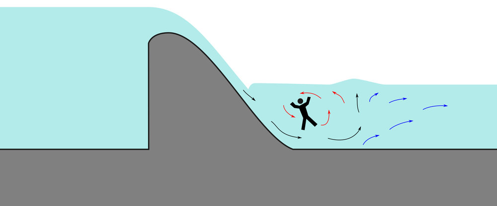
Even though the water around weirs can often appear relatively calm, they can be extremely dangerous places to boat, swim, or wade, as the circulation patterns on the downstream side - typically called a hydraulic jump - can submerge a person indefinitely. This phenomenon is so well known to canoeists, kayakers, and others who spend time on rivers that they even have a rueful name for weirs: "drowning machines".

There are dozens of these structures across the state, and most of them are not marked on maps. For trip planning, I have marked as many as I can find, except for the obvious ones that create lakes which are easily spotted even if they are not marked. Most of New Jersey's navigable waterways, lakes and ponds are artificially created.

https://practical.engineering/blog/2019/3/16/drowning-machine-the-dangers-of-low-head-dams

The Ohio DNR recommends that a victim should "tuck the chin down, draw the knees up to the chest with arms wrapped around them. Hopefully, conditions will be such that the current will push the victim along the bed of the river until swept beyond the boil line and released by the hydraulic." The Pennsylvania State Police also recommends to victims, "curl up, dive to the bottom, and swim or crawl downstream". As the hydraulic jump entrains air, the buoyancy of the water between the dam and boil line will be reduced by upward of 30%,* and if a victim is unable to float, escape at the base of the dam may be the only option for survival.

* In other words, your pfd is not going to save you!

While it is actually pretty hard to go over the top of most small dams, it is often easy to approach the bottom. The danger is more for swimmers than boaters, but if you fall out of the boat, you become a swimmer. So just stay away from these places.

Island Farm Weir, Bridgewater, New Jersey

The Island Farm Weir on the Raritan River drowned several people
( 40.54290, -74.56613 )

Note how the weir above is invisible on the map.
Switch to the satellite view, there it is!

Completion of the Island Farm Weir on the Raritan River occurred in October 1995. The Raritan River was classified by New Jersey as being suitable for recreational uses, including boating. Nevertheless, neither the owner, engineer, or the local government was inclined to install warning signs on the landings for boaters. Six months later, on April 12, 1996, a recreational canoeist paddled over the dam crest and was drowned in the recirculation flow of the reverse roller, while attempting to rescue his comrade, who had capsized. The river discharge on this date was 2,000 cfs over the 200-foot-long dam that was 8 feet high. The unit discharge was 10 cfs per foot. Following a total of four drownings, the dam was retrofitted to satisfactorily eliminate the reverse roller characteristic.

Even though the dam was 8 feet high, the hydraulic drop across the dam, from upstream to downstream, was only 2.8 feet, due to the stilling basin depth and the high tailwater conditions. At the crest of the dam, the velocity was 7 fps, with a depth of 1.55 feet. Meanwhile, where the overflow jet met the downstream pool, the velocity had increased to over 13 fps, with a Froude number of 2.8.
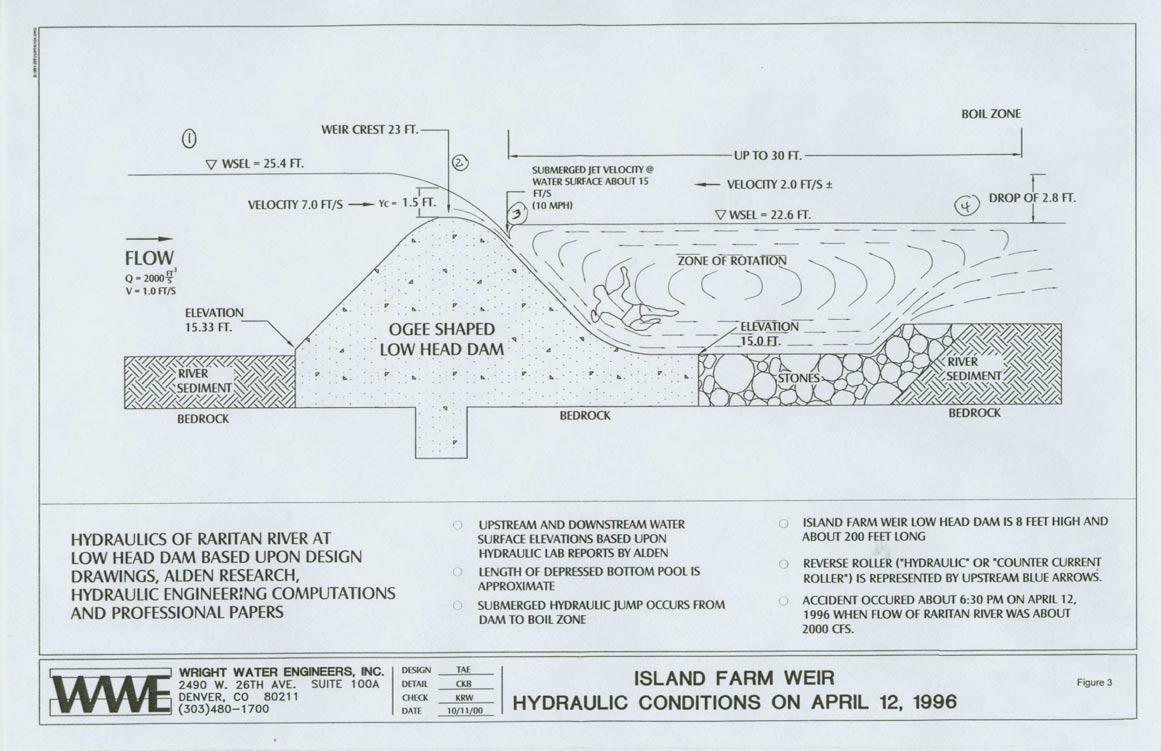
Figure 3 illustrates the dam and hydraulic characteristics at the time of the drowning and shows the length of the reverse roller at 30 feet, with an upstream velocity toward the dam of only a modest 2.0 fps; yet the current was able to trap the victim causing his expiration and the injury of two companions.

Prior to the subject drowning incident, a jet skier went up to the base of the dam where he was trapped and drowned. Then, following the subject event, a local television station was at the Island Farm Weir to do a piece on water hazards. During the filming, a canoeist unexpectedly appeared upstream and paddled over the dam crest. He capsized, his canoe bobbed (sometimes being vertical), and the victim drowned on the evening TV broadcast, his drowning being spectacularly recorded.

The Island Farm Weir was finally retrofitted in 1998 after four drownings in only three years following its construction. The successful retrofit consisted of merely flattening the downstream face of the dam by providing a series of steps to dissipate energy and to eliminate the opportunity for a reverse roller to form below the dam structure.
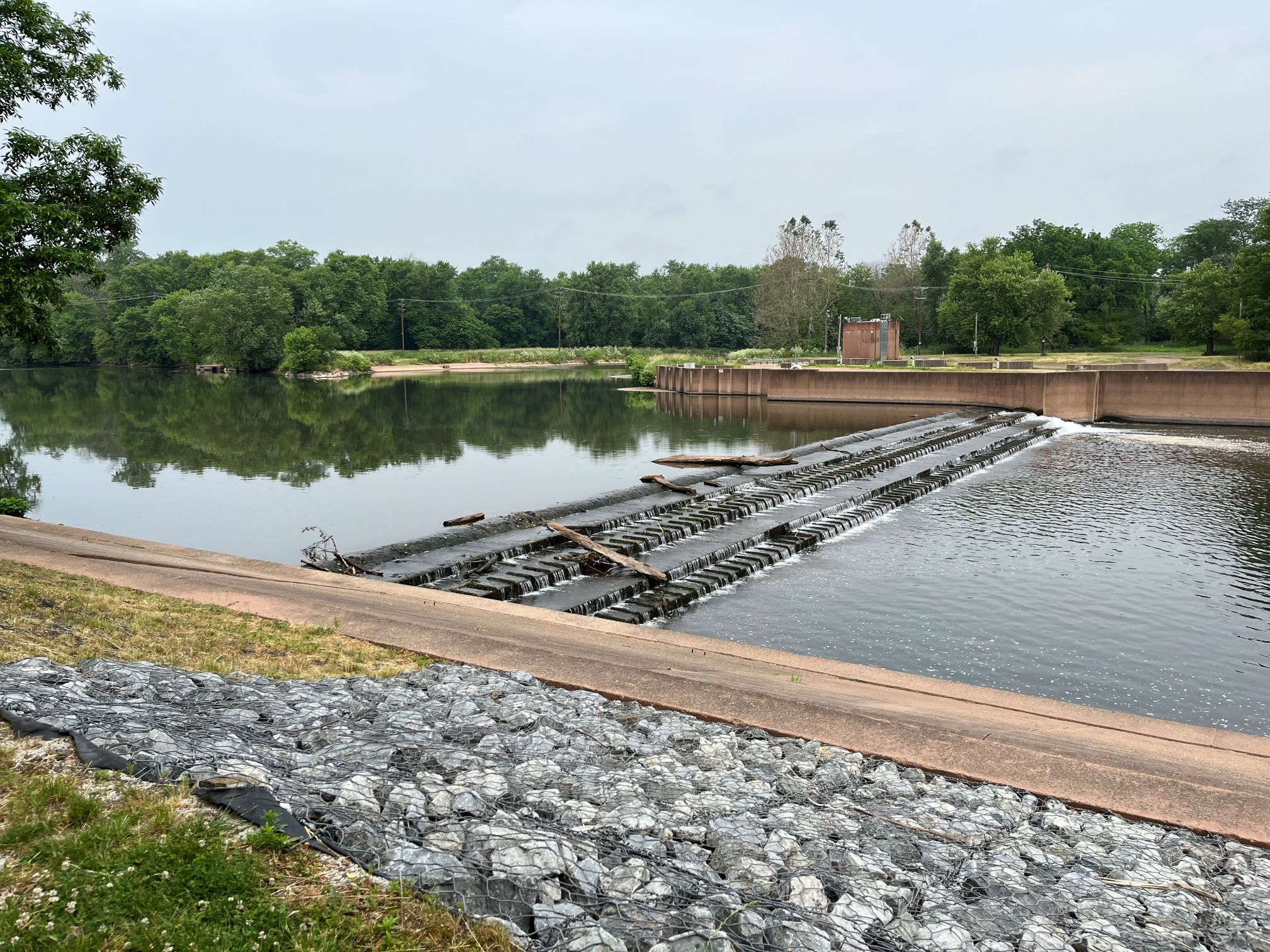
Island Farm Weir after modification, low flow
Note the fish ladder in the background.

Wright_PublicSafetyLowHead.pdf

Dams, Weirs and Falls
( 40.54520, -74.72257 )

The map above only shows the dams and weirs that might be obstacles. Many more actually create places to go! Flip through the map sources and you'll see just how poorly these structures are recorded. For example, the Island Farm Weir above is on neither the topographic nor the street map.

Burlington County
( 39.87142, -74.67547 )

  1. Atsion Lake - Pinelands ( 39.73989, -74.73128 )
  2. Bamber Lake - Lacey ( 39.89577, -74.31959 )
  3. Bass River - New Gretna ( 39.57721, -74.45079 )
  4. Batsto Lake - Batsto ( 39.64682, -74.65327 )
  5. Batsto River - Wharton State Forest ( 39.71014, -74.66747 )
  6. Big Timber Creek - Fort Nassau ( 39.88024, -75.12680 )
  7. Big Timber Creek - Glendora (N) ( 39.85285, -75.09452 )
  8. Big Timber Creek - Glendora (S) ( 39.83769, -75.08264 )
  9. Blackwood Lake - Big Timber Creek ( 39.80194, -75.07405 )
  10. Bunker Hill Bogs - Jackson ( 40.08255, -74.29256 )
  11. Cedar Creek - Berkeley ( 39.90248, -74.24513 )
  12. Cedar Creek - Double Trouble ( 39.89402, -74.22495 )
  13. Chip's Folly Campground ( 39.63281, -74.49799 )
  14. Collier's Lake - New Egypt ( 40.06799, -74.44856 )
  15. Cooper River - Haddonfield ( 39.90090, -75.02056 )
  16. Cooper River Lake - Collingswood ( 39.92432, -75.07123 )
  17. Cooper River Park - Haddonfield ( 39.92561, -75.05672 )
  18. Country Lake - Pemberton ( 39.94530, -74.54257 )
  19. Crosswick's Creek - Bordentown ( 40.14816, -74.71812 )
  20. Crosswick's Creek - Groveville ( 40.16705, -74.67717 )
  21. Crosswick's Creek - New Egypt (N) ( 40.08505, -74.54006 )
  22. Crosswick's Creek - New Egypt (S) ( 40.06679, -74.53226 )
  23. Crosswick's Creek - Walnford ( 40.13480, -74.55762 )
  24. D-R Canal - Trenton (S) ( 40.18384, -74.74666 )
  25. Deep Run - Wharton State Forest ( 39.76288, -74.69219 )
  26. Deer Head Lake ( 39.85043, -74.21101 )
  27. Delaware Canal - Morrisville PA ( 40.21792, -74.77976 )
  28. Delaware River - Beverly ( 40.06894, -74.92243 )
  29. Delaware River - Burlington ( 40.08236, -74.85662 )
  30. Delaware River - Burlington ( 40.08192, -74.85063 )
  31. Delaware River - Florence Twp ( 40.12238, -74.80412 )
  32. Delaware River - Frankford Creek ( 39.98473, -75.07171 )
  33. Delaware River - North Camden ( 39.95769, -75.11432 )
  34. Delaware River - Palmyra Cove ( 40.00916, -75.04176 )
  35. Delaware River - Pennsauken ( 39.98092, -75.06567 )
  36. Delaware River - Riverside ( 40.03775, -74.97833 )
  37. Delaware River - Trenton ( 40.18662, -74.75351 )
  38. Dramasel/Pines Lake ( 39.81713, -75.04735 )
  39. Great Egg Harbor River - New Brooklyn ( 39.70187, -74.93732 )
  40. Great Egg Harbor River - Penny Pot ( 39.57547, -74.82239 )
  41. Great Egg Harbor River - Piney Hollow Rd ( 39.62049, -74.89280 )
  42. Gropp Lake - White Horse ( 40.18761, -74.68888 )
  43. Hammonton Lake ( 39.63010, -74.78734 )
  44. Harry Wright Lake ( 39.93076, -74.35880 )
  45. Holiday Lake - Barnegat ( 39.73882, -74.26470 )
  46. Horicon Lake - Lakehurst ( 40.00720, -74.32177 )
  47. Indian Mills Lake ( 39.79554, -74.73998 )
  48. Kirkwood Lake - Cooper River ( 39.83637, -75.00105 )
  49. Lake Absegami - Bass River ( 39.62529, -74.42760 )
  50. Lake Success - Jackson ( 40.05785, -74.39243 )
  51. Laurel Lake ( 39.81720, -75.01032 )
  52. Lebanon Lake - Pemberton ( 39.90686, -74.56550 )
  53. Little Pine Lake - Pemberton ( 39.98857, -74.57096 )
  54. Makepeace Lake ( 39.54717, -74.75058 )
  55. Mirror Lake - Pemberton (N) ( 39.97209, -74.56941 )
  56. Mirror Lake - Pemberton (S) ( 39.96729, -74.57847 )
  57. Mullica River - Batsto ( 39.63973, -74.65889 )
  58. Mullica River - Crowley Landing ( 39.62640, -74.61922 )
  59. Mullica River - Hay Road Beach ( 39.57349, -74.53943 )
  60. Mullica River - Sweetwater Marina ( 39.62171, -74.62512 )
  61. Newton Creek - Johnson Park ( 39.89464, -75.11321 )
  62. Newton Lake - Collingswood ( 39.90840, -75.08179 )
  63. Oswego Lake - Penn State Forest ( 39.73454, -74.49111 )
  64. Oswego River - Martha Bridge ( 39.68159, -74.51416 )
  65. Pennsauken Creek - Cinnaminson (E) ( 39.97961, -75.00867 )
  66. Pennsauken Creek - Cinnaminson (W) ( 39.98056, -75.01119 )
  67. Pine Lake ( 40.00910, -74.24948 )
  68. Presidential Lakes - Pemberton ( 39.91110, -74.57680 )
  69. Prospertown Lake - Jackson ( 40.13497, -74.45779 )
  70. Rancocas Creek - Birmingham ( 39.97927, -74.70974 )
  71. Rancocas Creek - Hainesport ( 39.98489, -74.84372 )
  72. Rancocas Creek - Kirby's Mill ( 39.91685, -74.80555 )
  73. Rancocas Creek - Lumberton ( 39.96856, -74.81406 )
  74. Rancocas Creek - Medford Park ( 39.89713, -74.82061 )
  75. Rancocas Creek - Mt Holly (E) ( 39.99028, -74.77972 )
  76. Rancocas Creek - Mt Holly (W) ( 39.98980, -74.78956 )
  77. Rancocas Creek - New Lisbon ( 39.96205, -74.64102 )
  78. Rancocas Creek - Pemberton (E) ( 39.96746, -74.58789 )
  79. Rancocas Creek - Pemberton (W) ( 39.97030, -74.68377 )
  80. Rancocas Creek - Pemberton Heights ( 39.96244, -74.65567 )
  81. Rancocas Creek - Smithville ( 39.98571, -74.75083 )
  82. Rancocas Creek - Willingboro ( 40.02992, -74.92946 )
  83. Spring Lake ( 40.19512, -74.73217 )
  84. Stafford Forge WMA - Manahawkin ( 39.66881, -74.32090 )
  85. Stewart Lake - Woodbury ( 39.84193, -75.14283 )
  86. Stone Tavern Lake - Upper Freehold ( 40.19587, -74.48596 )
  87. Strawberry Lake - Moorestown ( 39.95460, -74.94940 )
  88. Strawbridge Lake - Moorestown ( 39.94984, -74.96347 )
  89. Sunken Branch - Toms River ( 39.96792, -74.24211 )
  90. Timber Creek ( 39.83638, -75.05988 )
  91. Toms River - Pine Lake Park ( 40.00353, -74.24106 )
  92. Turn Mill Pond - New Egypt ( 40.06371, -74.44772 )
  93. Wading River - Beaver Branch ( 39.65059, -74.51890 )
  94. Wading River - Bodine Field Road ( 39.65401, -74.52497 )
  95. Wading River - Evans Bridge ( 39.67517, -74.54066 )
  96. Wading River - Godfrey Bridge ( 39.68987, -74.54612 )
  97. Wading River - Harrisville Pond ( 39.66547, -74.52434 )
  98. Wading River - Hawkins Bridge ( 39.71442, -74.56595 )
  99. Wells Mills Pond ( 39.79387, -74.27701 )
  100. Whitesbog - Pemberton ( 39.96504, -74.48711 )
  101. Wilson Lake - Glassboro ( 39.65715, -75.05088 )