A Piece of Rope

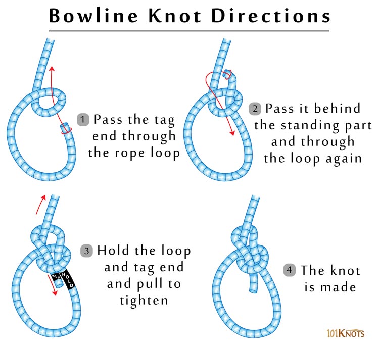
First of all, if you're going to be a sailor now, you'll have to learn that it is called "line", not "rope".

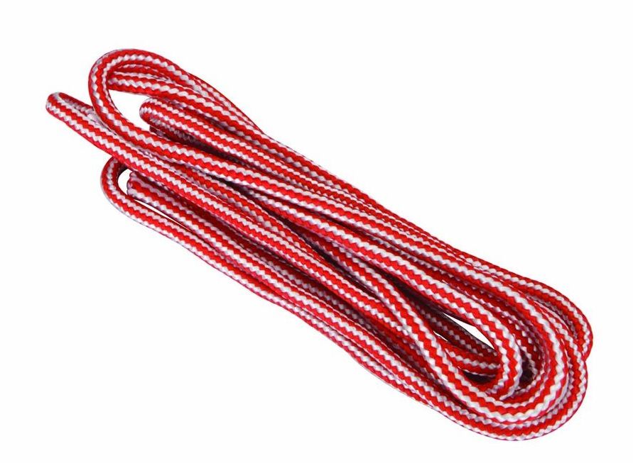
99 cents buys ten feet of 1/4" braided poly line (which floats) at Harbor Freight, or anywhere else. You never know what you might need it for, always have some on the boat somewhere. And if you're going to be a real mariner, learn to tie a bowline.

A piece of line can be very useful in getting in and out of the boat in tricky places. Just tie the line to the bow handle, and hold it as you climb out. You can then use the line to pull the boat up behind you, or tie it off.

I can never remember

Ten feet is plenty, more than that is just going to make a big tangle.


Atlantic County
( 39.49052, -74.63953 )

  1. Absecon Creek - Absecon ( 39.42635, -74.48653 )
  2. Atsion Lake - Pinelands ( 39.73989, -74.73128 )
  3. Barnegat Bay - Brant Beach ( 39.61673, -74.20110 )
  4. Barnegat Bay - Parkertown ( 39.60978, -74.29231 )
  5. Barnegat Bay - Tuckerton ( 39.57671, -74.33078 )
  6. Barnegat Bay - West Creek ( 39.63100, -74.29618 )
  7. Bass River - New Gretna ( 39.57721, -74.45079 )
  8. Batsto Lake - Batsto ( 39.64682, -74.65327 )
  9. Batsto River - Wharton State Forest ( 39.71014, -74.66747 )
  10. Bay Avenue - Ocean City ( 39.21643, -74.64678 )
  11. Cedar Run - Stafford ( 39.64365, -74.24592 )
  12. Cedar Swamp Creek (N) ( 39.26195, -74.70206 )
  13. Cedar Swamp Creek (S) ( 39.24889, -74.71257 )
  14. Deep Run - Wharton State Forest ( 39.76288, -74.69219 )
  15. Delaware River ( 40.17371, -74.84843 )
  16. Dennis Creek - Jake's Landing ( 39.17916, -74.85133 )
  17. East Creek Pond - Dennis ( 39.22333, -74.88656 )
  18. Franklinville Lake - Franklinville ( 39.61768, -75.07867 )
  19. Gibson's Creek ( 39.35592, -74.72609 )
  20. Great Bay - Graveling Point ( 39.53959, -74.38821 )
  21. Great Bay - Great Bay Blvd (N) ( 39.56316, -74.34202 )
  22. Great Bay - Great Bay Blvd (S) ( 39.52160, -74.31849 )
  23. Great Bay - Motts Creek ( 39.51826, -74.43637 )
  24. Great Bay - Rand's Marina ( 39.53934, -74.32614 )
  25. Great Egg Harbor Bay - Beerdley's Point ( 39.28756, -74.62664 )
  26. Great Egg Harbor Bay - Somers Point (N) ( 39.31130, -74.59272 )
  27. Great Egg Harbor Bay - Somers Point (S) ( 39.30640, -74.60763 )
  28. Great Egg Harbor River - Camp Acagisca ( 39.49275, -74.76715 )
  29. Great Egg Harbor River - Mays Landing ( 39.44940, -74.72489 )
  30. Great Egg Harbor River - New Brooklyn ( 39.70187, -74.93732 )
  31. Great Egg Harbor River - Penny Pot ( 39.57547, -74.82239 )
  32. Great Egg Harbor River - Piney Hollow Rd ( 39.62049, -74.89280 )
  33. Great Egg Harbor River - Weymouth ( 39.51339, -74.77889 )
  34. Hammonton Lake ( 39.63010, -74.78734 )
  35. Indian Mills Lake ( 39.79554, -74.73998 )
  36. Inside Thorofare - Atlantic City ( 39.35533, -74.45687 )
  37. Inside Thorofare - Ventnor ( 39.34593, -74.47623 )
  38. Lake Absegami - Bass River ( 39.62529, -74.42760 )
  39. Lake Lenape - Mays Landing ( 39.46187, -74.73755 )
  40. Lake Nummy - Belleplain ( 39.24691, -74.85720 )
  41. Lakes Bay - Ventnor ( 39.35318, -74.48744 )
  42. Longport Dog Beach ( 39.30741, -74.55738 )
  43. Ludlam Thorofare - Sea Isle City ( 39.14373, -74.70499 )
  44. Makepeace Lake ( 39.54717, -74.75058 )
  45. Malaga Lake - Newfield ( 39.57878, -75.05643 )
  46. Manahawkin Lake - Stafford ( 39.69641, -74.26116 )
  47. Maurice River - Alliance Beach ( 39.50198, -75.07976 )
  48. Maurice River - Garden Road ( 39.52199, -75.07329 )
  49. Maurice River - Mauricetown ( 39.28730, -74.98763 )
  50. Maurice River - Milleville ( 39.37706, -75.03671 )
  51. Maurice River - Sharp St ( 39.40012, -75.05345 )
  52. Maurice River - West Side Park ( 39.49608, -75.07611 )
  53. Maurice River - Willow Grove ( 39.54996, -75.07146 )
  54. Miller Creek ( 39.25262, -74.62715 )
  55. Mullica River - Batsto ( 39.63973, -74.65889 )
  56. Mullica River - Crowley Landing ( 39.62640, -74.61922 )
  57. Mullica River - Hay Road Beach ( 39.57349, -74.53943 )
  58. Nacote Creek - Port Republic ( 39.51768, -74.49363 )
  59. Oswego Lake - Penn State Forest ( 39.73454, -74.49111 )
  60. Oswego River - Martha Bridge ( 39.68159, -74.51416 )
  61. Patcong Creek - Bargaintown Pond ( 39.36083, -74.57569 )
  62. Patcong Creek - Belhaven ( 39.34363, -74.58752 )
  63. Patcong Creek - New Road ( 39.30470, -74.62031 )
  64. Reeds Bay - Absecon ( 39.44306, -74.46194 )
  65. Scull Bay - Bridge Out ( 39.34668, -74.55683 )
  66. Somers Bay - Brigantine ( 39.40916, -74.36937 )
  67. Stafford Forge WMA - Manahawkin ( 39.66881, -74.32090 )
  68. Stephen Creek ( 39.38564, -74.73649 )
  69. Stephen Creek - Maple Lake ( 39.40547, -74.77808 )
  70. Stephen Creek - Stephen Lake ( 39.39556, -74.74907 )
  71. Strathmere Bay - Strathmere ( 39.19447, -74.66326 )
  72. Tennessee Ave - Ocean City ( 39.27051, -74.60393 )
  73. Tuckahoe River - Corbin City ( 39.29883, -74.75319 )
  74. Tuckahoe River - Tuckahoe ( 39.29545, -74.74010 )
  75. Union Lake - Millville (E) ( 39.40677, -75.05152 )
  76. Union Lake - Millville (W) ( 39.40812, -75.06712 )
  77. Wading River - Beaver Branch ( 39.65059, -74.51890 )
  78. Wading River - Bodine Field Road ( 39.65401, -74.52497 )
  79. Wading River - Evans Bridge ( 39.67517, -74.54066 )
  80. Wading River - Godfrey Bridge ( 39.68987, -74.54612 )
  81. Wading River - Harrisville Pond ( 39.66547, -74.52434 )
  82. Wading River - Hawkins Bridge ( 39.71442, -74.56595 )
  83. Wilson Lake - Glassboro ( 39.65715, -75.05088 )

Printed from njkayak.net