Cable Lock

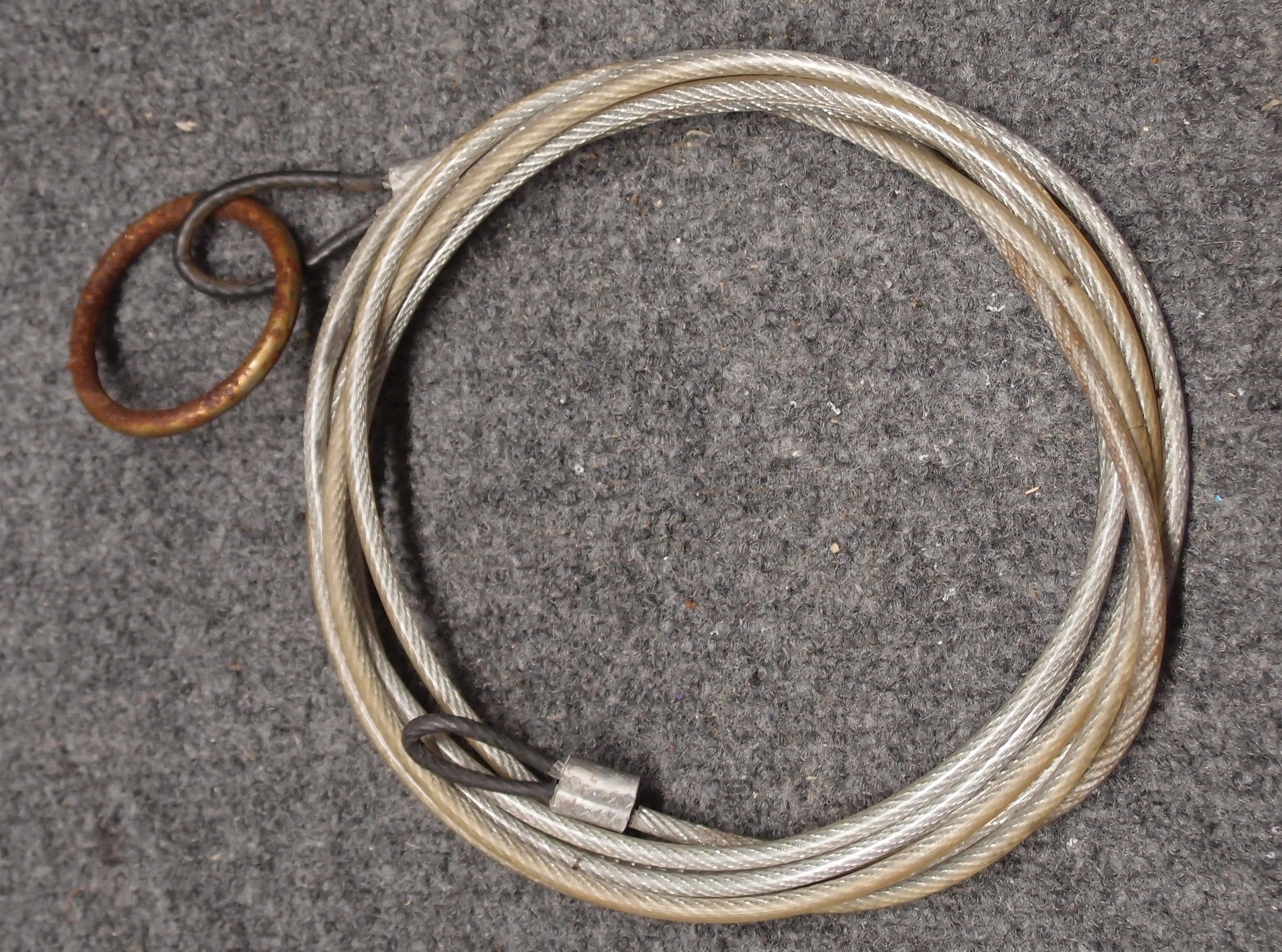
This is a cable-lock I made, about 12 feet long. It is just 3/16" coated steel cable from the hardware store, with crimp ferrules, and a big steel ring in one end. The ferrules fit through the scupper holes on the boat, but the steel ring does not. Together with any padlock, this will secure the boat (or several) to your truck, roof rack, a tree, or anything else that is handy. You can take this cable with you, it will give you peace of mind if you leave the boat unattended to go exploring on land.

The object is not to stop a determined thief - you can't do that. It is to stop someone from casually taking your boat with their bare hands. Don't lock the boat by the handles - they are easily cut with a pocket knife and cheap to replace. Run the cable through a scupper hole, and a thief would have to destroy the boat to steal it. If your boat doesn't have scupper holes, you can probably find someplace to thread the cable though, or make a suitable hole in the seat.

You can find a cable like this all set to go on Amazon for under 20 bucks. Where I used a steel ring, you could use a second padlock.


Atlantic County
( 39.49052, -74.63953 )

  1. Absecon Creek - Absecon ( 39.42635, -74.48653 )
  2. Atlantic City - Huron Ave ( 39.38023, -74.42392 )
  3. Atsion Lake - Pinelands ( 39.73989, -74.73128 )
  4. Barnegat Bay - Beach Haven ( 39.57015, -74.23933 )
  5. Barnegat Bay - Brant Beach ( 39.61673, -74.20110 )
  6. Barnegat Bay - Great Bay Blvd ( 39.56316, -74.34202 )
  7. Barnegat Bay - Little Egg Harbor ( 39.53556, -74.26441 )
  8. Barnegat Bay - Parkertown ( 39.60978, -74.29231 )
  9. Barnegat Bay - Tuckerton ( 39.57671, -74.33078 )
  10. Barnegat Bay - West Creek ( 39.63100, -74.29618 )
  11. Bass River - New Gretna ( 39.57721, -74.45079 )
  12. Batsto Lake - Batsto ( 39.64682, -74.65327 )
  13. Batsto River - Wharton State Forest ( 39.71014, -74.66747 )
  14. Bay Avenue - Ocean City ( 39.21643, -74.64678 )
  15. Cedar Run - Stafford ( 39.64365, -74.24592 )
  16. Cedar Swamp Creek (N) ( 39.26195, -74.70206 )
  17. Cedar Swamp Creek (S) ( 39.24889, -74.71257 )
  18. Chip's Folly Campground ( 39.63281, -74.49799 )
  19. Deep Run - Wharton State Forest ( 39.76288, -74.69219 )
  20. Dennis Creek - Jake's Landing ( 39.17916, -74.85133 )
  21. East Creek Pond - Dennis ( 39.22333, -74.88656 )
  22. Franklinville Lake - Franklinville ( 39.61768, -75.07867 )
  23. Gibson's Creek ( 39.35592, -74.72609 )
  24. Great Bay - Graveling Point ( 39.53949, -74.38761 )
  25. Great Bay - Great Bay Blvd ( 39.52160, -74.31849 )
  26. Great Bay - Great Bay Blvd (end) ( 39.50902, -74.32008 )
  27. Great Bay - Motts Creek ( 39.51826, -74.43637 )
  28. Great Bay - Rand's Marina ( 39.53934, -74.32614 )
  29. Great Egg Harbor Bay - Beerdley's Point ( 39.28756, -74.62664 )
  30. Great Egg Harbor Bay - Somers Point (N) ( 39.31130, -74.59272 )
  31. Great Egg Harbor Bay - Somers Point (S) ( 39.30640, -74.60763 )
  32. Great Egg Harbor River - Camp Acagisca ( 39.49275, -74.76715 )
  33. Great Egg Harbor River - Mays Landing ( 39.44940, -74.72489 )
  34. Great Egg Harbor River - New Brooklyn ( 39.70187, -74.93732 )
  35. Great Egg Harbor River - Penny Pot ( 39.57547, -74.82239 )
  36. Great Egg Harbor River - Piney Hollow Rd ( 39.62049, -74.89280 )
  37. Great Egg Harbor River - Weymouth ( 39.51339, -74.77889 )
  38. Hammonton Lake ( 39.63010, -74.78734 )
  39. Indian Mills Lake ( 39.79554, -74.73998 )
  40. Inside Thorofare - Atlantic City ( 39.35533, -74.45687 )
  41. Inside Thorofare - Ventnor ( 39.34593, -74.47623 )
  42. Lake Absegami - Bass River ( 39.62529, -74.42760 )
  43. Lake Lenape - Mays Landing ( 39.46187, -74.73755 )
  44. Lake Nummy - Belleplain ( 39.24691, -74.85720 )
  45. Lakes Bay - Ventnor ( 39.35318, -74.48744 )
  46. Longport Dog Beach ( 39.30741, -74.55738 )
  47. Ludlam Thorofare - Sea Isle City ( 39.14373, -74.70499 )
  48. Makepeace Lake ( 39.54717, -74.75058 )
  49. Malaga Lake - Newfield ( 39.57878, -75.05643 )
  50. Manahawkin Lake - Stafford ( 39.69641, -74.26116 )
  51. Maurice River - Alliance Beach ( 39.50198, -75.07976 )
  52. Maurice River - Garden Road ( 39.52199, -75.07329 )
  53. Maurice River - Mauricetown ( 39.28730, -74.98763 )
  54. Maurice River - Milleville ( 39.37706, -75.03671 )
  55. Maurice River - Sharp St ( 39.40012, -75.05345 )
  56. Maurice River - West Side Park ( 39.49608, -75.07611 )
  57. Maurice River - Willow Grove ( 39.54996, -75.07146 )
  58. Miller Creek ( 39.25262, -74.62715 )
  59. Mullica River - Batsto ( 39.63973, -74.65889 )
  60. Mullica River - Crowley Landing ( 39.62640, -74.61922 )
  61. Mullica River - Hay Road Beach ( 39.57349, -74.53943 )
  62. Mullica River - Sweetwater Marina ( 39.62171, -74.62512 )
  63. Nacote Creek - Port Republic ( 39.51768, -74.49363 )
  64. Oswego Lake - Penn State Forest ( 39.73454, -74.49111 )
  65. Oswego River - Martha Bridge ( 39.68159, -74.51416 )
  66. Patcong Creek - Bargaintown Pond ( 39.36083, -74.57569 )
  67. Patcong Creek - Belhaven ( 39.34363, -74.58752 )
  68. Patcong Creek - New Road ( 39.30470, -74.62031 )
  69. Reeds Bay - Absecon ( 39.44306, -74.46194 )
  70. Scull Bay - Bridge Out ( 39.34668, -74.55683 )
  71. Somers Bay - Brigantine ( 39.40916, -74.36937 )
  72. Stafford Forge WMA - Manahawkin ( 39.66881, -74.32090 )
  73. Stephen Creek ( 39.38564, -74.73649 )
  74. Stephen Creek - Maple Lake ( 39.40547, -74.77808 )
  75. Stephen Creek - Stephen Lake ( 39.39556, -74.74907 )
  76. Strathmere Bay - Strathmere ( 39.19447, -74.66326 )
  77. Tennessee Ave - Ocean City ( 39.27051, -74.60393 )
  78. Tuckahoe River - Corbin City ( 39.29883, -74.75319 )
  79. Tuckahoe River - Tuckahoe ( 39.29545, -74.74010 )
  80. Union Lake - Millville (E) ( 39.40677, -75.05152 )
  81. Union Lake - Millville (W) ( 39.40812, -75.06712 )
  82. Wading River - Beaver Branch ( 39.65059, -74.51890 )
  83. Wading River - Bodine Field Road ( 39.65401, -74.52497 )
  84. Wading River - Evans Bridge ( 39.67517, -74.54066 )
  85. Wading River - Godfrey Bridge ( 39.68987, -74.54612 )
  86. Wading River - Harrisville Pond ( 39.66547, -74.52434 )
  87. Wading River - Hawkins Bridge ( 39.71442, -74.56595 )
  88. Wilson Lake - Glassboro ( 39.65715, -75.05088 )