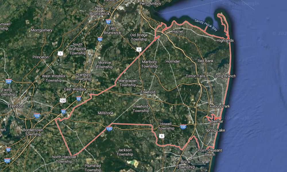
Municipal Boat Ramp - Keyport
This site is different, depending on when you go there. During the summer, and especially on weekends, there can be a lot of motorboats around. Other times, you can have the whole place to yourself.
When the ramp office is open the parking lot is only for the paid ramp users. In that case, you can park across Broad Street and lug your boat around the ramp to the little beach next to it. This is when a buddy or a set of wheels really comes in handy. If the office is closed, then go ahead and use the ramp lot, I've never had a problem.
Either way, launch off the beach, not the boat ramp, which is usually full of filth blown in by the wind. Immediately out from the beach you will find the boat channel. This is not a good place to be - either get across it or get away from it. Some of these boaters have no idea what "No Wake" means.
You can go three directions: left, right, or straight out. Straight out takes you across the boat channel into the sailboat anchorage. This is a nice place because you have lots of sailboats to look at, and no motorboats or jet-skis will go in there except the water taxi, which is slow. You can have a nice relaxing long paddle, half way to New York it feels like sometimes.
If you go to the right, you'll go past the old seaplane factory and then up towards Conaskonk Point. The wind picks up around the point and it gets choppy. Part way up to the point is Chingarora Creek, which is navigable for quite a long ways before it gets too small.
If you go to the left, you can just putz around in Keyport Harbor, or you can get ambitious and go up Matawan Creek, or cross over to the other side and go around Cliffwood. In the harbor, you can often hear music from the bars in Keyport. You'll need to give a wide berth to the fishing areas along the bulkhead. It is a tight squeeze under the Front Street bridge up Luppatatong Creek, which really leads nowhere and isn't worth doing.
But you can go very far up Matawan Creek - under Route 35 and the Garden State Parkway, all the way to the railroad, where the creek ends in a culvert. This is around 8 miles out and back. This route takes you right through all the marinas, so be careful and hug the shoreline. If not for the railroad bridge, you could get to where the 1916 shark attacks happened, and all the way up to the Lake Lefferts dam. I've never gone through the culvert, which would be the only access to that area.
If paddling makes you hungry, you are just steps away from Keyport's "Little Mexico" district, and there are good authentic Mexican places all around. Keyport itself is an interesting little town, full of beautifully-kept Victorian homes and old commercial buildings that somehow escaped getting torn down and turned into condos - it reminds me of Maine. They've done a really nice job on the waterfront. Take a walk around, get a piece of pizza or an ice cream cone.
Low tide is no problem here - it is just a longer slog across the beach.
If you scroll the map a bit to the right, you'll see an alternate launch point. This is a town park, and you can park the car on East Front Street. This area has been fixed-up quite a bit in the last year or two just for kayakers. It's a bit of a hump down to the water, but it puts you in a good ways east of the boat ramp, which makes a good starting place if you want to go around the point or explore the creek.
To the west, I have added another marker for the waterfront park in Cliffwood. If the bay is too rough, you can always head over to Lake Lefferts, 10 minutes away and weather-proof.
Lake Lefferts is a man-made lake, the result of the construction in 1928 of Lake Lefferts Dam, which captures and stores the flow of Matawan Creek. This is the nicest spot in northern Monmouth County. The lake is in three parts:
- The lower part that contains the dam and the launch area and extends up to the Route 34 bridge. This part is fairly deep and free of obstructions.
- The upper part from Route 34 to Route 516. This part is much shallower and weedy, especially at the far end.
- An unusable section beyond Route 516. This part is pretty much just mud.
More: Lake Lefferts - Matawan ...
Questions or Inquiries?
Just want to say Hello? Sign the .