Note: New Jersey law requires the wearing of a PFD from November 1 through May 1.

Seat Pads

The way you sit in a kayak places almost all your weight on your butt, and there is little way to vary your position. In a short time you can get very sore. If your kayak has any kind of seat pad at all, it is a thin hard cruel joke that does not help in the least.

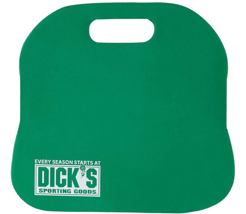
These thick neoprene foam bleacher cushions are a huge improvement over the thin pads that come with the boat ( if it even has those! ) Stack two for real comfort. Tie them to the seatback with a piece of bungie cord.

If your boat has an adjustable seat back, adjust it slightly forward of vertical. That way, when you lean on it, it will be straight and support your back the way it should.

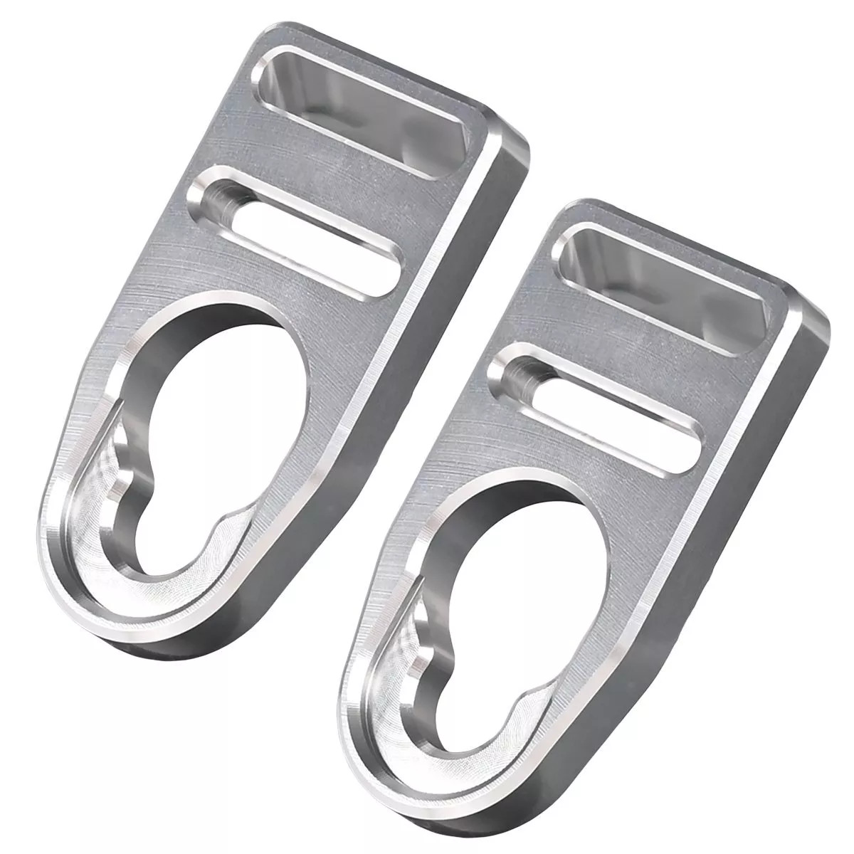
I also replaced the plastic seat-back strap buckles with these aluminium ones that will never break. You can find these on Amazoon or eBay.


Update:

I recently took the factory seat pad off my boat. I've come to the conclusion that it does nothing at all. I think it was just put there for looks. For whatever it is worth, I now sit a half inch lower in the boat. I also took the sun-beaten pad off the backrest, and don't miss it at all.


Atlantic County
( 39.49052, -74.63953 )

  1. Absecon Creek - Absecon ( 39.42635, -74.48653 )
  2. Atlantic City - Huron Ave ( 39.38023, -74.42392 )
  3. Atsion Lake - Pinelands ( 39.73989, -74.73128 )
  4. Barnegat Bay - Beach Haven ( 39.57015, -74.23933 )
  5. Barnegat Bay - Brant Beach ( 39.61673, -74.20110 )
  6. Barnegat Bay - Great Bay Blvd ( 39.56316, -74.34202 )
  7. Barnegat Bay - Little Egg Harbor ( 39.53556, -74.26441 )
  8. Barnegat Bay - Parkertown ( 39.60978, -74.29231 )
  9. Barnegat Bay - Tuckerton ( 39.57671, -74.33078 )
  10. Barnegat Bay - West Creek ( 39.63100, -74.29618 )
  11. Bass River - New Gretna ( 39.57721, -74.45079 )
  12. Batsto Lake - Batsto ( 39.64682, -74.65327 )
  13. Batsto River - Wharton State Forest ( 39.71014, -74.66747 )
  14. Bay Avenue - Ocean City ( 39.21643, -74.64678 )
  15. Cedar Run - Stafford ( 39.64365, -74.24592 )
  16. Cedar Swamp Creek (N) ( 39.26195, -74.70206 )
  17. Cedar Swamp Creek (S) ( 39.24889, -74.71257 )
  18. Chip's Folly Campground ( 39.63281, -74.49799 )
  19. Deep Run - Wharton State Forest ( 39.76288, -74.69219 )
  20. Dennis Creek - Jake's Landing ( 39.17916, -74.85133 )
  21. East Creek Pond - Dennis ( 39.22333, -74.88656 )
  22. Franklinville Lake - Franklinville ( 39.61768, -75.07867 )
  23. Gibson's Creek ( 39.35592, -74.72609 )
  24. Great Bay - Graveling Point ( 39.53949, -74.38761 )
  25. Great Bay - Great Bay Blvd ( 39.52160, -74.31849 )
  26. Great Bay - Great Bay Blvd (end) ( 39.50902, -74.32008 )
  27. Great Bay - Motts Creek ( 39.51826, -74.43637 )
  28. Great Bay - Rand's Marina ( 39.53934, -74.32614 )
  29. Great Egg Harbor Bay - Beerdley's Point ( 39.28756, -74.62664 )
  30. Great Egg Harbor Bay - Somers Point (N) ( 39.31130, -74.59272 )
  31. Great Egg Harbor Bay - Somers Point (S) ( 39.30640, -74.60763 )
  32. Great Egg Harbor River - Camp Acagisca ( 39.49275, -74.76715 )
  33. Great Egg Harbor River - Mays Landing ( 39.44940, -74.72489 )
  34. Great Egg Harbor River - New Brooklyn ( 39.70187, -74.93732 )
  35. Great Egg Harbor River - Penny Pot ( 39.57547, -74.82239 )
  36. Great Egg Harbor River - Piney Hollow Rd ( 39.62049, -74.89280 )
  37. Great Egg Harbor River - Weymouth ( 39.51339, -74.77889 )
  38. Hammonton Lake ( 39.63010, -74.78734 )
  39. Indian Mills Lake ( 39.79554, -74.73998 )
  40. Inside Thorofare - Atlantic City ( 39.35533, -74.45687 )
  41. Inside Thorofare - Ventnor ( 39.34593, -74.47623 )
  42. Lake Absegami - Bass River ( 39.62529, -74.42760 )
  43. Lake Lenape - Mays Landing ( 39.46187, -74.73755 )
  44. Lake Nummy - Belleplain ( 39.24691, -74.85720 )
  45. Lakes Bay - Ventnor ( 39.35318, -74.48744 )
  46. Longport Dog Beach ( 39.30741, -74.55738 )
  47. Ludlam Thorofare - Sea Isle City ( 39.14373, -74.70499 )
  48. Makepeace Lake ( 39.54717, -74.75058 )
  49. Malaga Lake - Newfield ( 39.57878, -75.05643 )
  50. Manahawkin Lake - Stafford ( 39.69641, -74.26116 )
  51. Maurice River - Alliance Beach ( 39.50198, -75.07976 )
  52. Maurice River - Garden Road ( 39.52199, -75.07329 )
  53. Maurice River - Mauricetown ( 39.28730, -74.98763 )
  54. Maurice River - Milleville ( 39.37706, -75.03671 )
  55. Maurice River - Sharp St ( 39.40012, -75.05345 )
  56. Maurice River - West Side Park ( 39.49608, -75.07611 )
  57. Maurice River - Willow Grove ( 39.54996, -75.07146 )
  58. Miller Creek ( 39.25262, -74.62715 )
  59. Mullica River - Batsto ( 39.63973, -74.65889 )
  60. Mullica River - Crowley Landing ( 39.62640, -74.61922 )
  61. Mullica River - Hay Road Beach ( 39.57349, -74.53943 )
  62. Mullica River - Sweetwater Marina ( 39.62171, -74.62512 )
  63. Nacote Creek - Port Republic ( 39.51768, -74.49363 )
  64. Oswego Lake - Penn State Forest ( 39.73454, -74.49111 )
  65. Oswego River - Martha Bridge ( 39.68159, -74.51416 )
  66. Patcong Creek - Bargaintown Pond ( 39.36083, -74.57569 )
  67. Patcong Creek - Belhaven ( 39.34363, -74.58752 )
  68. Patcong Creek - New Road ( 39.30470, -74.62031 )
  69. Reeds Bay - Absecon ( 39.44306, -74.46194 )
  70. Scull Bay - Bridge Out ( 39.34668, -74.55683 )
  71. Somers Bay - Brigantine ( 39.40916, -74.36937 )
  72. Stafford Forge WMA - Manahawkin ( 39.66881, -74.32090 )
  73. Stephen Creek ( 39.38564, -74.73649 )
  74. Stephen Creek - Maple Lake ( 39.40547, -74.77808 )
  75. Stephen Creek - Stephen Lake ( 39.39556, -74.74907 )
  76. Strathmere Bay - Strathmere ( 39.19447, -74.66326 )
  77. Tennessee Ave - Ocean City ( 39.27051, -74.60393 )
  78. Tuckahoe River - Corbin City ( 39.29883, -74.75319 )
  79. Tuckahoe River - Tuckahoe ( 39.29545, -74.74010 )
  80. Union Lake - Millville (E) ( 39.40677, -75.05152 )
  81. Union Lake - Millville (W) ( 39.40812, -75.06712 )
  82. Wading River - Beaver Branch ( 39.65059, -74.51890 )
  83. Wading River - Bodine Field Road ( 39.65401, -74.52497 )
  84. Wading River - Evans Bridge ( 39.67517, -74.54066 )
  85. Wading River - Godfrey Bridge ( 39.68987, -74.54612 )
  86. Wading River - Harrisville Pond ( 39.66547, -74.52434 )
  87. Wading River - Hawkins Bridge ( 39.71442, -74.56595 )
  88. Wilson Lake - Glassboro ( 39.65715, -75.05088 )