Cliffwood Beach - Aberdeen
- Lake Lefferts - Matawan ( 40.41563, -74.23362 )
- Raritan Bay - Cliffwood (E) ( 40.45089, -74.22033 )
- Raritan Bay - Cliffwood (W) ( 40.45216, -74.22269 )
- Raritan Bay - Cliffwood (Whale Creek) ( 40.45090, -74.22274 )
- Raritan Bay - Keyport (E) ( 40.44095, -74.19534 )
- Raritan Bay - Keyport (W) ( 40.43921, -74.20160 )
- Raritan Bay - Laurence Harbor (E) ( 40.45877, -74.24622 )
- Raritan Bay - Laurence Harbor (W) ( 40.46223, -74.25482 )
- Raritan Bay - South Amboy (N) ( 40.48343, -74.27059 )
- Raritan Bay - South Amboy (S) ( 40.47946, -74.26831 )
- Raritan Bay - South Amboy Ramp ( 40.48401, -74.27416 )
- Raritan Bay - Union Beach (E) ( 40.44787, -74.16598 )
- Raritan Bay - Union Beach (W) ( 40.45479, -74.17517 )
- Wagner's Marina - Matawan Creek ( 40.43540, -74.21416 )
The marker in the lower-center of the map is a super-easy put-in on Whale Creek, above. The other markers are a longer slog over the beach. All have convenient free parking (don't leave your vehicle in the launching area, that's a dick move!)
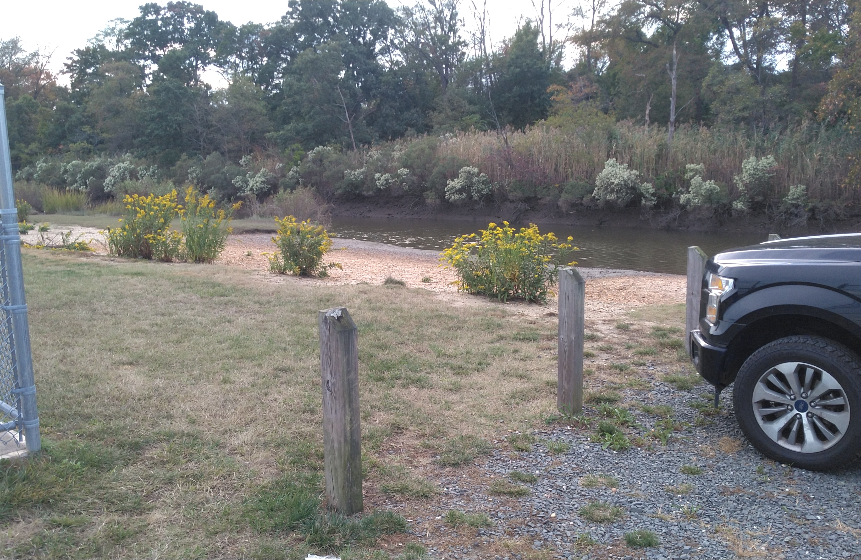
The creek is strongly tidal. At high water, you have a nice wide channel and can go almost to the highway. At low tide, not so much. The current can really rip under the bridge, bring your paddling muscles. In a strong current situation, it is best to go up-current on the outbound leg, and get a free ride back on the homeward leg.
If the bay is choppy, you can go up the creek, hopefully the wind will keep the flies down. If it is calm, go out the creek and explore the bay. If conditions here are just no good, pull back on the map, I have marked some alternates that are only minutes away.

Middlesex County, Monmouth County, Places,
- Arthur Kill - Buckingham Ave ( 40.51462, -74.25871 )
- Assunpink Access ( 40.23568, -74.58683 )
- Assunpink Lake - Upper Freehold ( 40.21542, -74.51702 )
- Barnegat Bay - Bay Harbor Park ( 40.01977, -74.12731 )
- Barnegat Bay - Mantoloking Bridge ( 40.04124, -74.05880 )
- Brainerd Lake - Cranbury ( 40.31113, -74.51178 )
- Buck's Pond - Colt's Neck ( 40.29178, -74.20380 )
- Bunker Hill Bogs - Jackson ( 40.08255, -74.29256 )
- Collier's Lake - New Egypt ( 40.06799, -74.44856 )
- Crosswick's Creek - New Egypt (N) ( 40.08505, -74.54006 )
- Crosswick's Creek - Walnford ( 40.13480, -74.55762 )
- Dallenbach Pond ( 40.41254, -74.44296 )
- Davidson's Mill Pond - East Brunswick ( 40.41117, -74.49789 )
- Deal Lake - Asbury Park (N) ( 40.23759, -74.00784 )
- Deal Lake - Asbury Park (S) ( 40.22957, -74.00938 )
- Etra Lake ( 40.25288, -74.49829 )
- Farrington Lake - East Brunswick (C) ( 40.42465, -74.47680 )
- Farrington Lake - East Brunswick (N) ( 40.43900, -74.46646 )
- Farrington Lake - East Brunswick (S) ( 40.42201, -74.48242 )
- Forge Pond - Brick ( 40.06646, -74.13446 )
- Grover's Mill Pond - Princeton Junction ( 40.31282, -74.60565 )
- Helmetta Pond ( 40.37817, -74.42657 )
- Horicon Lake - Lakehurst ( 40.00720, -74.32177 )
- Lake Carasaljo - Lakewood ( 40.09304, -74.22817 )
- Lake Lefferts - Matawan ( 40.41563, -74.23362 )
- Lake Manalapan - Jamesburg ( 40.34525, -74.43662 )
- Lake Riviera - Brick ( 40.04590, -74.14573 )
- Lake Shenandoah - Lakewood ( 40.08845, -74.19941 )
- Lake Success - Jackson ( 40.05785, -74.39243 )
- Lake Topanemus - Freehold ( 40.27635, -74.28554 )
- Lake Weamaconk - Englishtown ( 40.29140, -74.35704 )
- Lawrence Brook - Milltown (E) ( 40.45144, -74.43663 )
- Lawrence Brook - Milltown (W) ( 40.44831, -74.44367 )
- Manasquan Reservoir - Howell ( 40.17217, -74.20300 )
- Manasquan River - Allaire ( 40.14376, -74.11673 )
- Manasquan River - Beverly Beach ( 40.10498, -74.09649 )
- Manasquan River - Brice Park ( 40.13764, -74.11038 )
- Manasquan River - Dog Beach ( 40.10623, -74.03785 )
- Manasquan River - Glimmer Glass ( 40.11653, -74.04946 )
- Manasquan River - Howell ( 40.17519, -74.16981 )
- Manasquan River - Ramshorn Drive ( 40.11961, -74.09418 )
- Manasquan River - Riverfront Park ( 40.08835, -74.07142 )
- Manasquan River - RR Bridge ( 40.10052, -74.04905 )
- Manasquan River - WMA ( 40.13689, -74.10431 )
- Marlu Lake - Lincroft ( 40.33463, -74.15354 )
- Metedeconk River - Bay Ave ( 40.06602, -74.05130 )
- Metedeconk River - Bay Blvd ( 40.06288, -74.05502 )
- Metedeconk River - Bennett's Pond ( 40.13058, -74.28406 )
- Metedeconk River - Brick ( 40.05687, -74.11203 )
- Metedeconk River - Dock Rd ( 40.05055, -74.11413 )
- Metedeconk River - Sandy Point ( 40.05129, -74.07785 )
- Mill Pond - Princeton Meadows (E) ( 40.32460, -74.56567 )
- Mill Pond - Princeton Meadows (W) ( 40.32735, -74.60233 )
- Millhurst Pond - Freehold ( 40.24590, -74.34066 )
- Millstone River - Cranbury (E) ( 40.29359, -74.52675 )
- Millstone River - Cranbury (W) ( 40.29590, -74.56250 )
- Navesink River - Fair Haven ( 40.36647, -74.04204 )
- Navesink River - Red Bank ( 40.35212, -74.06980 )
- Navesink River - Rumson (E) ( 40.37649, -73.99990 )
- Navesink River - Rumson (W) ( 40.37650, -74.01310 )
- New Brunswick Water Utility ( 40.48340, -74.41271 )
- Peddie Lake - Hightstown ( 40.26870, -74.52219 )
- Perrineville Lake ( 40.22667, -74.43784 )
- Pine Lake ( 40.00910, -74.24948 )
- Prospertown Lake - Jackson ( 40.13497, -74.45779 )
- Raritan Bay - Atlantic Highlands ( 40.41858, -74.04652 )
- Raritan Bay - Cliffwood (E) ( 40.45089, -74.22033 )
- Raritan Bay - Cliffwood (W) ( 40.45216, -74.22269 )
- Raritan Bay - Cliffwood (Whale Creek) ( 40.45090, -74.22274 )
- Raritan Bay - Highlands ( 40.40340, -73.98494 )
- Raritan Bay - Keyport (E) ( 40.44095, -74.19534 )
- Raritan Bay - Keyport (W) ( 40.43921, -74.20160 )
- Raritan Bay - Laurence Harbor (E) ( 40.45877, -74.24622 )
- Raritan Bay - Laurence Harbor (W) ( 40.46223, -74.25482 )
- Raritan Bay - Leonardo ( 40.42375, -74.06122 )
- Raritan Bay - Middletown ( 40.44463, -74.11175 )
- Raritan Bay - Port Monmouth ( 40.43800, -74.08955 )
- Raritan Bay - Sandy Hook ( 40.41555, -73.98161 )
- Raritan Bay - South Amboy (N) ( 40.48343, -74.27059 )
- Raritan Bay - South Amboy (S) ( 40.47946, -74.26831 )
- Raritan Bay - South Amboy Ramp ( 40.48401, -74.27416 )
- Raritan Bay - Union Beach (E) ( 40.44787, -74.16598 )
- Raritan Bay - Union Beach (W) ( 40.45479, -74.17517 )
- Raritan River - Edison ( 40.48791, -74.38382 )
- Raritan River - Highland Park ( 40.48864, -74.42226 )
- Raritan River - New Brunswick ( 40.48760, -74.43280 )
- Raritan River - Perth Amboy ( 40.50057, -74.27712 )
- Raritan River - Sayreville ( 40.47450, -74.35606 )
- Rising Sun Lake - Upper Freehold ( 40.20699, -74.46339 )
- Rocky Brook - Hightstown ( 40.27108, -74.52353 )
- Shadow Lake - Middletown ( 40.34698, -74.10476 )
- Shark River - Belmar ( 40.17946, -74.03743 )
- Shark River - Neptune ( 40.19364, -74.03092 )
- Shark River - Wall Township ( 40.19149, -74.05792 )
- Shrewsbury River - Blackberry Park ( 40.32556, -74.00672 )
- Shrewsbury River - Branchport ( 40.31165, -74.00316 )
- Shrewsbury River - Fort Monmouth ( 40.32337, -74.03355 )
- Shrewsbury River - Galilee ( 40.34273, -73.97625 )
- Shrewsbury River - Long Branch ( 40.32594, -73.99006 )
- Shrewsbury River - Monmouth Beach ( 40.32805, -73.98631 )
- Shrewsbury River - North Rd ( 40.33662, -73.98315 )
- Shrewsbury River - Oceanport Creek ( 40.31460, -74.02877 )
- Shrewsbury River - Rumson ( 40.35672, -73.98569 )
- Shrewsbury River - Sea Bright (E) ( 40.36542, -73.97673 )
- Shrewsbury River - Sea Bright (W) ( 40.36263, -73.98172 )
- Shrewsbury River - Seawaneka Ave ( 40.33023, -74.00426 )
- Shrewsbury River - Somers Scout Park ( 40.33016, -74.00132 )
- South River - Old Bridge ( 40.41228, -74.36362 )
- South River - Sayreville ( 40.45397, -74.37222 )
- South River - South River ( 40.45838, -74.38361 )
- Stockton Lake - Manasquan ( 40.11739, -74.03460 )
- Stone Tavern Lake - Upper Freehold ( 40.19587, -74.48596 )
- Swimming River - Middletown ( 40.34831, -74.08318 )
- Swimming River - Red Bank ( 40.33838, -74.08815 )
- Toms River - Pine Lake Park ( 40.00353, -74.24106 )
- Turkey Swamp Park - Freehold ( 40.19577, -74.30435 )
- Turn Mill Pond - New Egypt ( 40.06371, -74.44772 )
- Twilight Lake - Bay Head ( 40.07474, -74.04404 )
- Wagner's Marina - Matawan Creek ( 40.43540, -74.21416 )
- Weston's Mill Pond - East Brunswick ( 40.46677, -74.42603 )
- Wreck Pond - Sea Girt ( 40.13880, -74.02726 )
- Wreck Pond - Spring Lake ( 40.14107, -74.04003 )
More: Monmouth County ...
- Lake Lefferts - Matawan ( 40.41563, -74.23362 )
- Raritan Bay - Cliffwood (E) ( 40.45089, -74.22033 )
- Raritan Bay - Cliffwood (W) ( 40.45216, -74.22269 )
- Raritan Bay - Cliffwood (Whale Creek) ( 40.45090, -74.22274 )
- Raritan Bay - Keyport (W) ( 40.43921, -74.20160 )
- Raritan Bay - Laurence Harbor (E) ( 40.45877, -74.24622 )
- Raritan Bay - Laurence Harbor (W) ( 40.46223, -74.25482 )
- Raritan Bay - South Amboy (N) ( 40.48343, -74.27059 )
- Raritan Bay - South Amboy (S) ( 40.47946, -74.26831 )
- Raritan Bay - South Amboy Ramp ( 40.48401, -74.27416 )
- Raritan River - Perth Amboy ( 40.50057, -74.27712 )
- Wagner's Marina - Matawan Creek ( 40.43540, -74.21416 )
Much of this part or Raritan Bay is fenced-off because of lead pollution from the industrial slag used to build jetties and seawalls in the 1970s. Supposedly, most of it has been cleaned up, but the whole area remains 'off-limits'. Since the toxins leach into the water and are carried off by the currents, you really have to wonder about the entire bay. A quick search online will reveal more on this subject than you ever wanted to know.
More: Laurence Harbor / Cheesequake Creek ...
- Lake Lefferts - Matawan ( 40.41563, -74.23362 )
- Raritan Bay - Cliffwood (E) ( 40.45089, -74.22033 )
- Raritan Bay - Cliffwood (W) ( 40.45216, -74.22269 )
- Raritan Bay - Cliffwood (Whale Creek) ( 40.45090, -74.22274 )
- Raritan Bay - Keyport (E) ( 40.44095, -74.19534 )
- Raritan Bay - Keyport (W) ( 40.43921, -74.20160 )
- Raritan Bay - Laurence Harbor (E) ( 40.45877, -74.24622 )
- Raritan Bay - Laurence Harbor (W) ( 40.46223, -74.25482 )
- Raritan Bay - Union Beach (E) ( 40.44787, -74.16598 )
- Raritan Bay - Union Beach (W) ( 40.45479, -74.17517 )
- Wagner's Marina - Matawan Creek ( 40.43540, -74.21416 )
This site varies, depending on when you go there. During the summer, and especially on weekends, there can be a lot of motorboats around. Other times, you can have the whole place to yourself.
More: Keyport ...
- Lake Lefferts - Matawan ( 40.41563, -74.23362 )
- Raritan Bay - Cliffwood (E) ( 40.45089, -74.22033 )
- Raritan Bay - Cliffwood (W) ( 40.45216, -74.22269 )
- Raritan Bay - Cliffwood (Whale Creek) ( 40.45090, -74.22274 )
- Raritan Bay - Keyport (E) ( 40.44095, -74.19534 )
- Raritan Bay - Keyport (W) ( 40.43921, -74.20160 )
- Raritan Bay - Laurence Harbor (E) ( 40.45877, -74.24622 )
- Raritan Bay - Laurence Harbor (W) ( 40.46223, -74.25482 )
- Wagner's Marina - Matawan Creek ( 40.43540, -74.21416 )
Lake Lefferts is a man-made lake, the result of the construction in 1928 of Lake Lefferts Dam, which captures and stores the flow of Matawan Creek. This is the nicest spot in northern Monmouth County. The lake is in three parts:
- The lower part that contains the dam and the launch area and extends up to the Route 34 bridge. This part is fairly deep and free of obstructions.
- The upper part from Route 34 to Route 516. This part is much shallower and weedy, especially at the far end.
- An unusable section beyond Route 516. This part is pretty much just mud. It may look like water, but trust me - don't go there.
More: Lake Lefferts - Matawan ...
Questions or Inquiries?
Just want to say Hello? Sign the .