Navesink River
- Navesink River - Fair Haven ( 40.36647, -74.04204 )
- Navesink River - Red Bank ( 40.35212, -74.06980 )
- Navesink River - Rumson (E) ( 40.37649, -73.99990 )
- Navesink River - Rumson (W) ( 40.37650, -74.01310 )
- Shadow Lake - Middletown ( 40.34698, -74.10476 )
- Swimming River - Middletown ( 40.34831, -74.08318 )
- Swimming River - Red Bank ( 40.33838, -74.08815 )
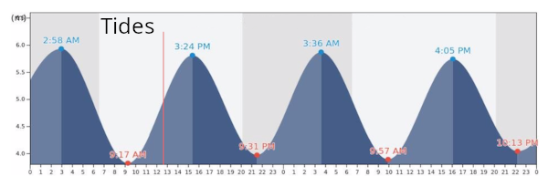
The Navesink River is more like a big brackish lake, except where it narrows-down and connects to Raritan Bay. While it is tidal, most of the river has negligible current, although it is wide enough to get choppy if the wind is strong. The water is generally clean, unlike the nearby Swimming River. Boat traffic is not too bad either.
No matter where you start from, the Navesink offers beautiful and interesting views along both banks. Nice houses and the Red Bank “skyline” along the south shore, and mansions along the north shore, including Governor Murphy’s place not far from the 35 bridge, and the Bon Jovi estate.
The one place to stay away from is where the river narrows-down near Sea Bright – the boat traffic is heavy and the tidal current can be very strong.

- Arthur Kill - Buckingham Ave ( 40.51462, -74.25871 )
- Arthur Kill - Ferry St ( 40.54576, -74.25424 )
- Assunpink Lake - Upper Freehold ( 40.21542, -74.51702 )
- Brainerd Lake - Cranbury ( 40.31113, -74.51178 )
- Buck's Pond - Colt's Neck ( 40.29178, -74.20380 )
- Bunker Hill Bogs - Jackson ( 40.08255, -74.29256 )
- Collier's Lake - New Egypt ( 40.06799, -74.44856 )
- Crosswick's Creek - New Egypt (N) ( 40.08505, -74.54006 )
- Crosswick's Creek - Walnford ( 40.13480, -74.55762 )
- Dallenbach Pond ( 40.41254, -74.44296 )
- Davidson's Mill Pond - East Brunswick ( 40.41117, -74.49789 )
- Deal Lake - Asbury Park (N) ( 40.23759, -74.00784 )
- Deal Lake - Asbury Park (S) ( 40.22957, -74.00938 )
- Delaware River ( 40.17371, -74.84843 )
- Etra Lake ( 40.25288, -74.49829 )
- Farrington Lake - East Brunswick (C) ( 40.42465, -74.47680 )
- Farrington Lake - East Brunswick (N) ( 40.43900, -74.46646 )
- Farrington Lake - East Brunswick (S) ( 40.42201, -74.48242 )
- Forge Pond - Brick ( 40.06646, -74.13446 )
- Helmetta Pond ( 40.37817, -74.42657 )
- Lake Carasaljo - Lakewood ( 40.09304, -74.22817 )
- Lake Lefferts - Matawan ( 40.41563, -74.23362 )
- Lake Manalapan - Jamesburg ( 40.34525, -74.43662 )
- Lake Riviera - Brick ( 40.04590, -74.14573 )
- Lake Shenandoah - Lakewood ( 40.08845, -74.19941 )
- Lake Success - Jackson ( 40.05785, -74.39243 )
- Lake Topanemus - Freehold ( 40.27635, -74.28554 )
- Lake Weamaconk - Englishtown ( 40.29140, -74.35704 )
- Lawrence Brook - Milltown (E) ( 40.45144, -74.43663 )
- Lawrence Brook - Milltown (W) ( 40.44831, -74.44367 )
- Manasquan Reservoir - Howell ( 40.17217, -74.20300 )
- Manasquan River - Allaire ( 40.14376, -74.11673 )
- Manasquan River - Beverly Beach ( 40.10498, -74.09649 )
- Manasquan River - Brice Park ( 40.13764, -74.11038 )
- Manasquan River - Dog Beach ( 40.10623, -74.03785 )
- Manasquan River - Glimmer Glass ( 40.11653, -74.04946 )
- Manasquan River - Howell ( 40.17519, -74.16981 )
- Manasquan River - Ramshorn Drive ( 40.11961, -74.09418 )
- Manasquan River - Riverfront Park ( 40.08835, -74.07142 )
- Manasquan River - RR Bridge ( 40.10052, -74.04905 )
- Manasquan River - WMA ( 40.13689, -74.10431 )
- Marlu Lake - Lincroft ( 40.33463, -74.15354 )
- Metedeconk River - Bay Ave ( 40.06602, -74.05130 )
- Metedeconk River - Bay Blvd ( 40.06288, -74.05502 )
- Metedeconk River - Bennett's Pond ( 40.13058, -74.28406 )
- Metedeconk River - Brick ( 40.05687, -74.11203 )
- Metedeconk River - Dock Rd ( 40.05055, -74.11413 )
- Metedeconk River - Sandy Point ( 40.05129, -74.07785 )
- Mill Pond - Princeton Meadows (E) ( 40.32460, -74.56567 )
- Millhurst Pond - Freehold ( 40.24590, -74.34066 )
- Millstone River - Cranbury (E) ( 40.29359, -74.52675 )
- Millstone River - Cranbury (W) ( 40.29590, -74.56250 )
- Navesink River - Fair Haven ( 40.36647, -74.04204 )
- Navesink River - Red Bank ( 40.35212, -74.06980 )
- Navesink River - Rumson (E) ( 40.37649, -73.99990 )
- Navesink River - Rumson (W) ( 40.37650, -74.01310 )
- Peddie Lake - Hightstown ( 40.26870, -74.52219 )
- Perrineville Lake ( 40.22667, -74.43784 )
- Prospertown Lake - Jackson ( 40.13497, -74.45779 )
- Raritan Bay - Atlantic Highlands ( 40.41858, -74.04652 )
- Raritan Bay - Cliffwood (E) ( 40.45089, -74.22033 )
- Raritan Bay - Cliffwood (W) ( 40.45216, -74.22269 )
- Raritan Bay - Cliffwood (Whale Creek) ( 40.45090, -74.22274 )
- Raritan Bay - Highlands ( 40.40340, -73.98494 )
- Raritan Bay - Keyport (E) ( 40.44095, -74.19534 )
- Raritan Bay - Keyport (W) ( 40.43921, -74.20160 )
- Raritan Bay - Laurence Harbor (E) ( 40.45877, -74.24622 )
- Raritan Bay - Laurence Harbor (W) ( 40.46223, -74.25482 )
- Raritan Bay - Leonardo ( 40.42375, -74.06122 )
- Raritan Bay - Middletown ( 40.44463, -74.11175 )
- Raritan Bay - Port Monmouth ( 40.43800, -74.08955 )
- Raritan Bay - Sandy Hook ( 40.41555, -73.98161 )
- Raritan Bay - South Amboy (N) ( 40.48343, -74.27059 )
- Raritan Bay - South Amboy (S) ( 40.47946, -74.26831 )
- Raritan Bay - South Amboy Ramp ( 40.48401, -74.27416 )
- Raritan Bay - Union Beach (E) ( 40.44787, -74.16598 )
- Raritan Bay - Union Beach (W) ( 40.45479, -74.17517 )
- Raritan River - Edison ( 40.48791, -74.38382 )
- Raritan River - Highland Park ( 40.48864, -74.42226 )
- Raritan River - New Brunswick ( 40.48760, -74.43280 )
- Raritan River - Perth Amboy ( 40.50057, -74.27712 )
- Raritan River - Sayreville ( 40.47450, -74.35606 )
- Rising Sun Lake - Upper Freehold ( 40.20699, -74.46339 )
- Rocky Brook - Hightstown ( 40.27108, -74.52353 )
- Shadow Lake - Middletown ( 40.34698, -74.10476 )
- Shark River - Belmar ( 40.17946, -74.03743 )
- Shark River - Neptune ( 40.19364, -74.03092 )
- Shark River - Wall Township ( 40.19149, -74.05792 )
- Shrewsbury River - Blackberry Park ( 40.32556, -74.00672 )
- Shrewsbury River - Branchport ( 40.31165, -74.00316 )
- Shrewsbury River - Fort Monmouth ( 40.32337, -74.03355 )
- Shrewsbury River - Galilee ( 40.34273, -73.97625 )
- Shrewsbury River - Little Silver ( 40.33685, -74.01600 )
- Shrewsbury River - Long Branch ( 40.32594, -73.99006 )
- Shrewsbury River - Monmouth Beach ( 40.32805, -73.98631 )
- Shrewsbury River - North Rd ( 40.33662, -73.98315 )
- Shrewsbury River - Oceanport Creek ( 40.31460, -74.02877 )
- Shrewsbury River - Rumson ( 40.35672, -73.98569 )
- Shrewsbury River - Sea Bright (E) ( 40.36542, -73.97673 )
- Shrewsbury River - Sea Bright (W) ( 40.36263, -73.98172 )
- Shrewsbury River - Seawaneka Ave ( 40.33023, -74.00426 )
- Shrewsbury River - Somers Scout Park ( 40.33016, -74.00132 )
- South River - Old Bridge ( 40.41228, -74.36362 )
- South River - Sayreville ( 40.45397, -74.37222 )
- South River - South River ( 40.45838, -74.38361 )
- Stockton Lake - Manasquan ( 40.11739, -74.03460 )
- Stone Tavern Lake - Upper Freehold ( 40.19587, -74.48596 )
- Swimming River - Middletown ( 40.34831, -74.08318 )
- Swimming River - Red Bank ( 40.33838, -74.08815 )
- Turkey Swamp Park - Freehold ( 40.19577, -74.30435 )
- Twilight Lake - Bay Head ( 40.07474, -74.04404 )
- Wagner's Marina - Matawan Creek ( 40.43540, -74.21416 )
- Weston's Mill Pond - East Brunswick ( 40.46677, -74.42603 )
- Wreck Pond - Sea Girt ( 40.13880, -74.02726 )
- Wreck Pond - Spring Lake ( 40.14107, -74.04003 )
Monmouth County is located in the central portion of the U.S. state of New Jersey. It is bordered to its west by Mercer, Middlesex and Burlington Counties, to its south by Ocean County, to its east by the Atlantic Ocean, and to its north by the Raritan Bay (sharing a border with the boroughs of Staten Island, Brooklyn, and Queens in New York City, across it). Monmouth County’s geographic area comprises 30% water.
More: Monmouth County …
- Navesink River - Fair Haven ( 40.36647, -74.04204 )
- Navesink River - Red Bank ( 40.35212, -74.06980 )
- Navesink River - Rumson (E) ( 40.37649, -73.99990 )
- Navesink River - Rumson (W) ( 40.37650, -74.01310 )
- Shadow Lake - Middletown ( 40.34698, -74.10476 )
- Swimming River - Middletown ( 40.34831, -74.08318 )
- Swimming River - Red Bank ( 40.33838, -74.08815 )
The Swimming River is an extension of the Navesink. On the map above, you can see the main put-in is at the upper-right in the new (2015) county park. You need to check in at the ranger’s hut; there is a ramp fee of $7 per vessel, including kayaks and canoes. The park also has a strict closing time, at which the gates are locked. For details, see the county’s page here:
- https://www.monmouthcountyparks.com/page.aspx?ID=4545
More: Swimming River …
- Shrewsbury River - Blackberry Park ( 40.32556, -74.00672 )
- Shrewsbury River - Branchport ( 40.31165, -74.00316 )
- Shrewsbury River - Fort Monmouth ( 40.32337, -74.03355 )
- Shrewsbury River - Galilee ( 40.34273, -73.97625 )
- Shrewsbury River - Little Silver ( 40.33685, -74.01600 )
- Shrewsbury River - Long Branch ( 40.32594, -73.99006 )
- Shrewsbury River - Monmouth Beach ( 40.32805, -73.98631 )
- Shrewsbury River - North Rd ( 40.33662, -73.98315 )
- Shrewsbury River - Oceanport Creek ( 40.31460, -74.02877 )
- Shrewsbury River - Rumson ( 40.35672, -73.98569 )
- Shrewsbury River - Sea Bright (E) ( 40.36542, -73.97673 )
- Shrewsbury River - Sea Bright (W) ( 40.36263, -73.98172 )
- Shrewsbury River - Seawaneka Ave ( 40.33023, -74.00426 )
- Shrewsbury River - Somers Scout Park ( 40.33016, -74.00132 )
The dirt ramp at Tocci Avenue in Monmouth Beach is free.
More: Shrewsbury River …
- Navesink River - Fair Haven ( 40.36647, -74.04204 )
- Navesink River - Red Bank ( 40.35212, -74.06980 )
- Navesink River - Rumson (E) ( 40.37649, -73.99990 )
- Navesink River - Rumson (W) ( 40.37650, -74.01310 )
- Shadow Lake - Middletown ( 40.34698, -74.10476 )
- Swimming River - Middletown ( 40.34831, -74.08318 )
- Swimming River - Red Bank ( 40.33838, -74.08815 )
This small lake is about a mile long. The only public launch is at the west end in Stevenson Park, off West Front Street. There is a channel from there to the lake, but good luck finding it – be prepared to run aground. Fortunately, the bottom is firm sand, and a short tow on foot will get you out to deeper water. It is also possible to go a short ways up the creek.
More: Shadow Lake – Middletown …

Questions or Inquiries?
Just want to say Hello? Sign the .