Sandy Hook

Well, it's that time of year again, time to renew the web hosting. And for those of you that don't know, that has become a lot more expensive than it used to be. Fifty dollars a year is now several hundred. Not to mention the price of domain names has gone up ten-fold.

And I just found out that the nice folks at PayPal disabled all my Support buttons, and I never got a notice (although that may be my fault.) In any case, it is all working again now, so if you would like to make a small donation to help defray these costs, it would be greatly appreciated.

Sandy Hook
( 40.43847, -74.04611 )

  1. Raritan Bay - Atlantic Highlands ( 40.41858, -74.04652 )
  2. Raritan Bay - Cliffwood (E) ( 40.45089, -74.22033 )
  3. Raritan Bay - Cliffwood (W) ( 40.45216, -74.22269 )
  4. Raritan Bay - Cliffwood (Whale Creek) ( 40.45090, -74.22274 )
  5. Raritan Bay - Highlands ( 40.40340, -73.98494 )
  6. Raritan Bay - Keyport (E) ( 40.44095, -74.19534 )
  7. Raritan Bay - Keyport (W) ( 40.43921, -74.20160 )
  8. Raritan Bay - Laurence Harbor (E) ( 40.45877, -74.24622 )
  9. Raritan Bay - Laurence Harbor (W) ( 40.46223, -74.25482 )
  10. Raritan Bay - Leonardo ( 40.42375, -74.06122 )
  11. Raritan Bay - Middletown ( 40.44463, -74.11175 )
  12. Raritan Bay - Port Monmouth ( 40.43800, -74.08955 )
  13. Raritan Bay - Sandy Hook ( 40.41555, -73.98161 )
  14. Raritan Bay - South Amboy (N) ( 40.48343, -74.27059 )
  15. Raritan Bay - South Amboy (S) ( 40.47946, -74.26831 )
  16. Raritan Bay - South Amboy Ramp ( 40.48401, -74.27416 )
  17. Raritan Bay - Union Beach (E) ( 40.44787, -74.16598 )
  18. Raritan Bay - Union Beach (W) ( 40.45479, -74.17517 )

I have marked Lot C on the bay side, which is the best combination of parking and access to the water. This spot is very popular with windsurfers. You could also use Spermacetti Cove to the north. On a very fine day, you could even try the ocean side.

There is a fee to enter the park in the summer season, it is free after Labor Day. Before Memorial Day might be chilly.
Raritan Bay - Sandy Hook
( 40.41555, -73.98161 )

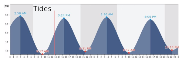
Tides

Comments on Sandy Hook

Questions or Inquiries?

Just want to say Hello? Sign the .

Submit a Comment

Your email address will not be published. Required fields are marked *


Click image to replace if unable to read.

Enter the digits from the image above, except for the last one:

This site uses Akismet to reduce spam. Learn how your comment data is processed.


Shark River
( 40.18786, -74.03461 )

  1. Shark River - Belmar ( 40.17946, -74.03743 )
  2. Shark River - Neptune ( 40.19364, -74.03092 )
  3. Shark River - Wall Township ( 40.19149, -74.05792 )

Shark River is not really a river, it is more of a saltwater lagoon with an outlet to the sea. The actual inlet would be a very bad place to go, with a lot of boat traffic and sometimes swift tidal current. The lagoon is much better, and I have marked two spots that are easy access and parking - both in public parks. Don't try to use the boat ramp, you might get in trouble.

Printed from njkayak.net