Swifts & Swallows

Well, it's that time of year again, time to renew the web hosting. And for those of you that don't know, that has become a lot more expensive than it used to be. Fifty dollars a year is now several hundred. Not to mention the price of domain names has gone up ten-fold.

And I just found out that the nice folks at PayPal disabled all my Support buttons, and I never got a notice (although that may be my fault.) In any case, it is all working again now, so if you would like to make a small donation to help defray these costs, it would be greatly appreciated.

These are small birds that are often seen over water. They both feed on flying insects, which they catch on the wing, and over water seems to be a good place to do that. At night, these birds are replaced by bats, doing the same thing. You are unlikely to get a good look at any of these, as they are all very fast and agile fliers.

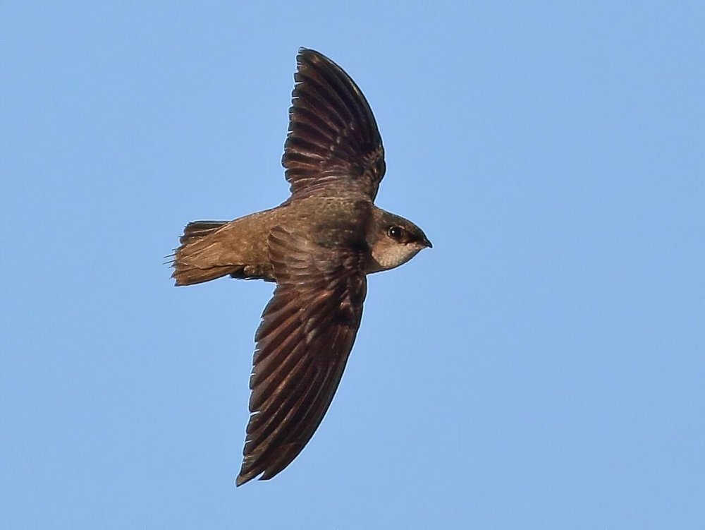
Chimney Swift
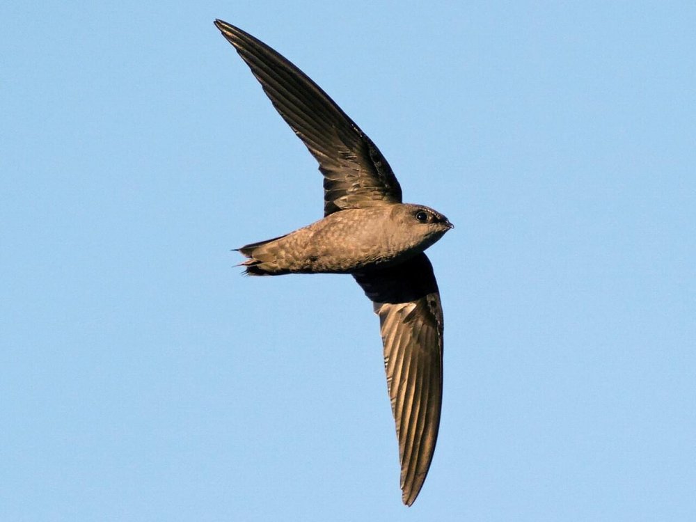
Note the almost absence of a tail and straight wings of the Chimney Swift.

-- Wikipedia


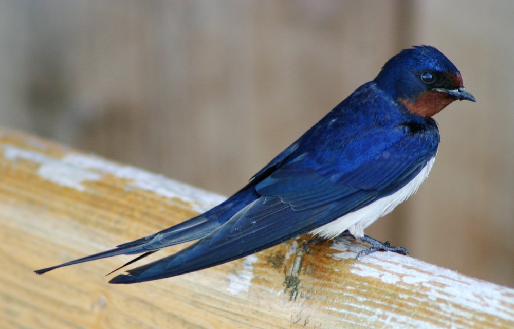
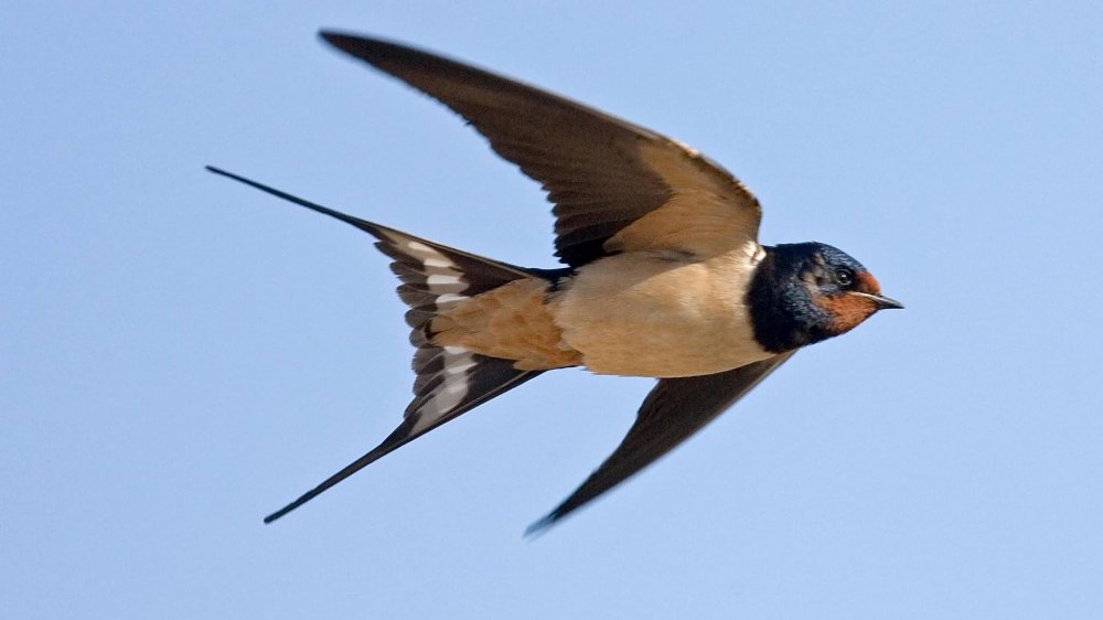
Barn Swallow

Note the graceful forked tail and swept wings of the Barn Swallow.

-- Wikipedia


You are unlikely to ever see anything of either of these birds except a dark silhouette against the sky. Nontheless, they are easy to tell apart. While both are highly acrobatic in flight, neither is as downright erratic as a bat. No need to worry about bats - they have excellent senses, and the last thing they want to do is crash into you!

Mercer County
( 40.28435, -74.67324 )

  1. Assunpink Dam Access ( 40.23568, -74.58683 )
  2. Assunpink Lake - Upper Freehold ( 40.21542, -74.51702 )
  3. Brainerd Lake - Cranbury ( 40.31113, -74.51178 )
  4. Collier's Lake - New Egypt ( 40.06799, -74.44856 )
  5. Colonial Lake - Lawrence ( 40.25527, -74.72369 )
  6. Crosswick's Creek - Groveville ( 40.16705, -74.67717 )
  7. Crosswick's Creek - New Egypt (N) ( 40.08505, -74.54006 )
  8. Crosswick's Creek - New Egypt (S) ( 40.06679, -74.53226 )
  9. Crosswick's Creek - Walnford ( 40.13480, -74.55762 )
  10. D-R Canal - Amwell Rd ( 40.50340, -74.58268 )
  11. D-R Canal - Blackwells Mills ( 40.47550, -74.57220 )
  12. D-R Canal - Griggstown (N) ( 40.43834, -74.61397 )
  13. D-R Canal - Griggstown (S) ( 40.42912, -74.61816 )
  14. D-R Canal - Kingston (N) ( 40.37489, -74.61854 )
  15. D-R Canal - Kingston (S) ( 40.37326, -74.61861 )
  16. D-R Canal - Lawrence (N) ( 40.27450, -74.70332 )
  17. D-R Canal - Lawrence (S) ( 40.26746, -74.71071 )
  18. D-R Canal - Lawrenceville ( 40.30501, -74.68490 )
  19. D-R Canal - Manville ( 40.52861, -74.58178 )
  20. D-R Canal - New Brunswick ( 40.50806, -74.46376 )
  21. D-R Canal - North Trenton ( 40.24901, -74.72865 )
  22. D-R Canal - Plainsboro (E) ( 40.34321, -74.62964 )
  23. D-R Canal - Plainsboro (W) ( 40.34190, -74.63758 )
  24. D-R Canal - Princeton (N) ( 40.33879, -74.64715 )
  25. D-R Canal - Princeton (S) ( 40.33177, -74.65282 )
  26. D-R Canal - Province Line Rd ( 40.30273, -74.68819 )
  27. D-R Canal - Rocky Hill ( 40.39826, -74.62702 )
  28. D-R Canal - Somerset (N) ( 40.54077, -74.51404 )
  29. D-R Canal - Somerset (S) ( 40.52390, -74.49248 )
  30. D-R Canal - Trenton (N) ( 40.23886, -74.74194 )
  31. D-R Canal - Trenton (S) ( 40.18384, -74.74666 )
  32. D-R Canal - West Windsor ( 40.30844, -74.67979 )
  33. D-R Feeder Canal - Lambertville (S) ( 40.34206, -74.94044 )
  34. D-R Feeder Canal - Rt 202 ( 40.37987, -74.95175 )
  35. D-R Feeder Canal - Scudders Falls ( 40.26529, -74.84790 )
  36. D-R Feeder Canal - Washington Crossing ( 40.29842, -74.86852 )
  37. D-R Feeder Canal - West Trenton ( 40.24497, -74.81917 )
  38. Dallenbach Pond ( 40.41254, -74.44296 )
  39. Davidson's Mill Pond - East Brunswick ( 40.41117, -74.49789 )
  40. Delaware Canal - Morrisville PA ( 40.21792, -74.77976 )
  41. Delaware Canal - New Hope ( 40.37983, -74.95835 )
  42. Delaware Canal - Newtown PA ( 40.26858, -74.86017 )
  43. Delaware Canal - Washington's X'ing PA ( 40.29014, -74.87709 )
  44. Delaware Canal - Yardley PA ( 40.23742, -74.82909 )
  45. Delaware River - Beverly ( 40.06894, -74.92243 )
  46. Delaware River - Bordentown ( 40.14816, -74.71812 )
  47. Delaware River - Burlington ( 40.08236, -74.85662 )
  48. Delaware River - Burlington ( 40.08192, -74.85063 )
  49. Delaware River - Florence Twp ( 40.12238, -74.80412 )
  50. Delaware River - Lambertville (N) ( 40.36072, -74.94531 )
  51. Delaware River - Lambertville (S) ( 40.34235, -74.94193 )
  52. Delaware River - Titusville ( 40.30711, -74.88066 )
  53. Delaware River - Trenton ( 40.18662, -74.75351 )
  54. Dick's Sporting Goods - West Windsor ( 40.30691, -74.67877 )
  55. East Amwell Lake ( 40.40023, -74.84316 )
  56. Etra Lake ( 40.25288, -74.49829 )
  57. Farrington Lake - East Brunswick (C) ( 40.42465, -74.47680 )
  58. Farrington Lake - East Brunswick (N) ( 40.43900, -74.46646 )
  59. Farrington Lake - East Brunswick (S) ( 40.42201, -74.48242 )
  60. Gropp Lake - White Horse ( 40.18761, -74.68888 )
  61. Grover's Mill Pond - Princeton Junction ( 40.31282, -74.60565 )
  62. Helmetta Pond ( 40.37817, -74.42657 )
  63. Lake Carnegie - Plainsboro ( 40.34362, -74.62973 )
  64. Lake Carnegie - Princeton ( 40.36681, -74.62597 )
  65. Lake Luxembourg - Langhorne PA ( 40.20011, -74.91904 )
  66. Lake Manalapan - Jamesburg ( 40.34525, -74.43662 )
  67. Lake Weamaconk - Englishtown ( 40.29140, -74.35704 )
  68. Lawrence Brook - Milltown (E) ( 40.45144, -74.43663 )
  69. Lawrence Brook - Milltown (W) ( 40.44831, -74.44367 )
  70. Mercer Lake - Hamilton ( 40.26561, -74.64191 )
  71. Mercer Lake - West Windsor ( 40.26960, -74.64114 )
  72. Mill Pond - Princeton Meadows (E) ( 40.32460, -74.56567 )
  73. Mill Pond - Princeton Meadows (W) ( 40.32735, -74.60233 )
  74. Millhurst Pond - Freehold ( 40.24590, -74.34066 )
  75. Millstone River - Amwell Rd ( 40.50294, -74.58755 )
  76. Millstone River - Blackwells Mills ( 40.47487, -74.57503 )
  77. Millstone River - Cranbury (E) ( 40.29359, -74.52675 )
  78. Millstone River - Cranbury (W) ( 40.29590, -74.56250 )
  79. Millstone River - Griggstown ( 40.43893, -74.61757 )
  80. Millstone River - Kingston ( 40.37419, -74.61962 )
  81. Millstone River - Manville ( 40.53124, -74.58753 )
  82. Millstone River - Plainsboro (N) ( 40.34262, -74.62981 )
  83. Millstone River - Plainsboro (S) ( 40.33874, -74.62880 )
  84. Millstone River - Rocky Hill (N) ( 40.39957, -74.62809 )
  85. Millstone River - Rocky Hill (S) ( 40.39969, -74.62867 )
  86. Millstone River - West Windsor ( 40.32139, -74.60831 )
  87. Miry Run ( 40.24052, -74.64696 )
  88. Neshaminy Creek - Newtown PA ( 40.23271, -74.97409 )
  89. Peddie Lake - Hightstown ( 40.26870, -74.52219 )
  90. Perrineville Lake ( 40.22667, -74.43784 )
  91. Prospertown Lake - Jackson ( 40.13497, -74.45779 )
  92. Raritan River - Branchburg ( 40.55644, -74.68838 )
  93. Raritan River - Duke Island (E) ( 40.56082, -74.64751 )
  94. Raritan River - Duke Island (W) ( 40.55279, -74.68330 )
  95. Raritan River - Highland Park ( 40.48864, -74.42226 )
  96. Raritan River - New Brunswick ( 40.48760, -74.43280 )
  97. Raritan River - Piscataway (N) ( 40.54085, -74.51236 )
  98. Raritan River - Piscataway (S) ( 40.50935, -74.46641 )
  99. Raritan River - Power Canal ( 40.55112, -74.67136 )
  100. Raritan River - Raritan ( 40.56492, -74.63884 )
  101. Raritan River South Branch ( 40.54640, -74.69603 )
  102. Raritan River South Branch - Flemington (C) ( 40.52105, -74.82666 )
  103. Raritan River South Branch - Flemington (E) ( 40.50354, -74.77814 )
  104. Raritan River South Branch - Flemington (N) ( 40.53810, -74.83934 )
  105. Raritan River South Branch - Neshanic (E) ( 40.50873, -74.72776 )
  106. Raritan River South Branch - Neshanic (W) ( 40.50250, -74.74182 )
  107. Rising Sun Lake - Upper Freehold ( 40.20699, -74.46339 )
  108. Rocky Brook - Hightstown ( 40.27108, -74.52353 )
  109. South River - Old Bridge ( 40.41228, -74.36362 )
  110. South River - Sayreville ( 40.45397, -74.37222 )
  111. South River - South River ( 40.45838, -74.38361 )
  112. Spring Lake ( 40.19512, -74.73217 )
  113. Stone Tavern Lake - Upper Freehold ( 40.19587, -74.48596 )
  114. Stony Brook - Pennington ( 40.33257, -74.75809 )
  115. Stony Brook - Princeton ( 40.33219, -74.65340 )
  116. Stony Brook - Rosedale ( 40.33168, -74.77828 )
  117. Turn Mill Pond - New Egypt ( 40.06371, -74.44772 )
  118. Weston's Mill Pond - East Brunswick ( 40.46677, -74.42603 )

The thin red line is the "fall line" - the nominal division between uplands and lowlands.

Printed from njkayak.net