Note: New Jersey law requires the wearing of a PFD from November 1 through May 1.

Snakes

Common Watersnake

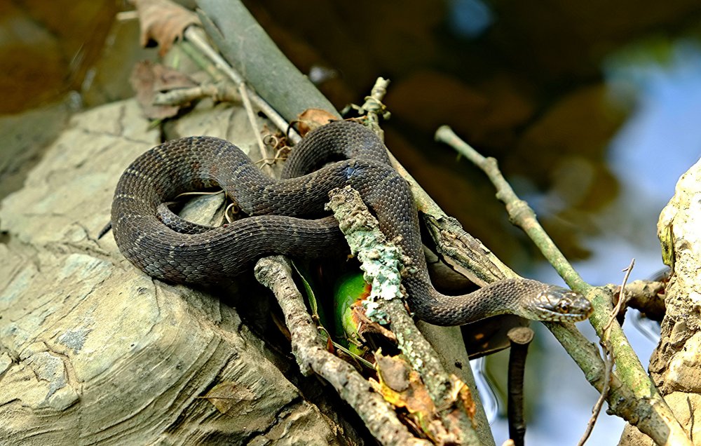
This is one of the most common snakes in NJ, inhabiting freshwater streams, ponds, lakes, swamps, marshes, and bogs throughout the state. This snake will likely retreat from you, but if you have to push your luck, this bad-tempered critter can give you a nasty non-venomous bite, and is likely to hold on for quite a while. All snakes are good swimmers, but this one actually likes the water.

-- Wikipedia


Other Snakes

New Jersey has a lot of other snakes, only two of which are dangerously venomous. Unless you are an expert, it is best to leave any snake alone. Garter Snakes can also be found in and around water, and have recently been found to be venomous, although their bite is about as toxic as a bee sting.
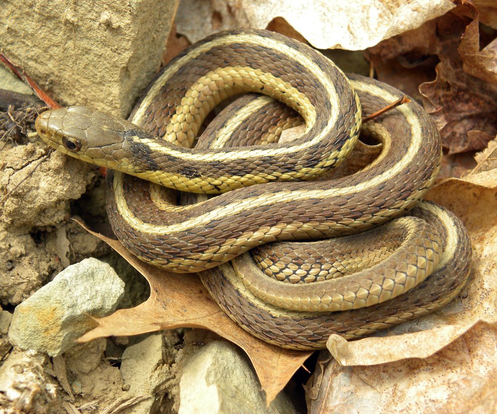
Eastern Garter Snake

-- Wikipedia


Morris County
( 40.86405, -74.52438 )

  1. Branch Brook Park ( 40.75077, -74.18305 )
  2. Budd Lake - Hackettstown ( 40.86292, -74.75154 )
  3. Clinton Reservoir (N) ( 41.09734, -74.44232 )
  4. Clinton Reservoir (S) ( 41.09409, -74.44102 )
  5. Cranberry Lake - Andover ( 40.95204, -74.73681 )
  6. Echo Lake - Mountainside ( 40.67351, -74.34560 )
  7. Lake Aeroflex - Andover ( 41.01041, -74.73564 )
  8. Lake Hopatcong - Ashley's Cove ( 40.96426, -74.61082 )
  9. Lake Hopatcong - Hopatcong (E) ( 40.92890, -74.63861 )
  10. Lake Hopatcong - Hopatcong (W) ( 40.91763, -74.66346 )
  11. Lake Musconetcong - Netcong ( 40.90099, -74.70354 )
  12. Lake Musconetcong - Port Morris Park ( 40.90851, -74.68505 )
  13. Lake Surprise - Summit ( 40.69343, -74.37003 )
  14. Lamington/Black River - Ironia Rd ( 40.83520, -74.64481 )
  15. Lamington/Black River - Pleasant Hill Rd ( 40.80333, -74.69788 )
  16. Lamington/Black River - Pottersville ( 40.71374, -74.72011 )
  17. Lamington/Black River - Righter Rd ( 40.85089, -74.63450 )
  18. Lamington/Black River - Route 10 ( 40.86048, -74.62893 )
  19. Lamington/Black River - Washington Tpk. ( 40.77881, -74.72098 )
  20. Morris Canal - Waterloo ( 40.91259, -74.76785 )
  21. Mountain Lake - Denville ( 40.88952, -74.44225 )
  22. Musconetcong River - Beattystown (N) ( 40.82340, -74.83263 )
  23. Musconetcong River - Beattystown (S) ( 40.81291, -74.84166 )
  24. Musconetcong River - Hackettstown ( 40.83466, -74.82278 )
  25. Musconetcong River - Saxton ( 40.88829, -74.79732 )
  26. Musconetcong River - Stephens SP ( 40.87225, -74.80619 )
  27. Musconetcong River - Waterloo (N) ( 40.91147, -74.76912 )
  28. Musconetcong River - Waterloo (S) ( 40.89663, -74.79111 )
  29. Musconetcong River - WMA ( 40.80501, -74.85012 )
  30. Orange Reservoir - Rahway River ( 40.75964, -74.28903 )
  31. Passaic River - Basking Ridge ( 40.69503, -74.51600 )
  32. Passaic River - Chatham ( 40.73795, -74.37159 )
  33. Passaic River - Chatham ( 40.72583, -74.38948 )
  34. Passaic River - Dead River ( 40.65005, -74.52464 )
  35. Passaic River - East Hanover (N) ( 40.82749, -74.33529 )
  36. Passaic River - East Hanover (S) ( 40.82581, -74.33332 )
  37. Passaic River - Fairfield ( 40.89775, -74.27988 )
  38. Passaic River - Livingston ( 40.77879, -74.36862 )
  39. Passaic River - Warren ( 40.67078, -74.46441 )
  40. Paulins Kill - access ( 41.07478, -74.78607 )
  41. Peaquannock River - Appelt Park ( 41.00189, -74.31640 )
  42. Peaquannock River - Oak Ridge Reservoir ( 41.06314, -74.48597 )
  43. Peaquannock River - Riverdale ( 40.99137, -74.29694 )
  44. Peaquannock River - Riverdale Rd ( 40.98818, -74.29319 )
  45. Peckman River - Cedar Grove ( 40.85861, -74.22711 )
  46. Pequest River - Allamuchy ( 40.92160, -74.84089 )
  47. Pequest River - Hackettstown ( 40.86630, -74.90540 )
  48. Pines Lake - Pompton ( 40.98952, -74.26212 )
  49. Pompton River - Follari Tract ( 40.98011, -74.29032 )
  50. Pompton River - Lincoln Park ( 40.91475, -74.27182 )
  51. Pompton River - River Drive ( 40.98153, -74.29748 )
  52. Potash Lake - Ramapo River ( 41.02250, -74.25936 )
  53. Rahway River - Cranford (N) ( 40.66036, -74.30627 )
  54. Rahway River - Cranford (S) ( 40.65097, -74.30133 )
  55. Rahway River - Cranford (W) ( 40.65900, -74.30997 )
  56. Rahway River - Lenape Park ( 40.67407, -74.31426 )
  57. Rahway River - Mohawk Park ( 40.64041, -74.29408 )
  58. Rahway River - Nomahegan Lake ( 40.66832, -74.31741 )
  59. Rahway River - South Mountain ( 40.73112, -74.30704 )
  60. Rahway River - Springfield ( 40.70824, -74.30186 )
  61. Ramapo River - Great Oak Park ( 41.01630, -74.26106 )
  62. Ramapo River - Pompton Lake (E) ( 41.00056, -74.27621 )
  63. Ramapo River - Pompton Lake (N) ( 41.00602, -74.27796 )
  64. Ramapo River - Pompton Lake (W) ( 41.00392, -74.28272 )
  65. Ramapo River - Stiles Park ( 40.98695, -74.28014 )
  66. Raritan River North Branch ( 40.60018, -74.67447 )
  67. Raritan River North Branch - Far Hills ( 40.68441, -74.64214 )
  68. Raritan River North Branch - Natirar Park ( 40.64761, -74.68024 )
  69. Rockaway River - Boonton ( 40.91556, -74.42705 )
  70. Rockaway River - Denville (E) ( 40.89625, -74.47500 )
  71. Rockaway River - Denville (W) ( 40.89916, -74.48675 )
  72. Rockaway River - McCarter Park ( 40.89122, -74.47349 )
  73. Rockaway River - Montville ( 40.89893, -74.37344 )
  74. Rockaway River - Pine Brook ( 40.86608, -74.35202 )
  75. Rockaway River - Rockaway (E) ( 40.90190, -74.50881 )
  76. Rockaway River - Rockaway (W) ( 40.89737, -74.51528 )
  77. Rockaway River - Towpath Rd ( 40.90322, -74.46364 )
  78. Rockaway River - Wharton ( 40.88947, -74.56952 )
  79. Rockaway River - WMA ( 40.95537, -74.57069 )
  80. Speedwell Lake - Morristown ( 40.81265, -74.48090 )
  81. Split Rock Reservoir - Rockaway ( 40.96274, -74.45808 )
  82. Sunset Lake ( 40.87071, -74.61751 )
  83. Tilcon Lake - Waterloo ( 40.90717, -74.76840 )
  84. Verona Lake - Montclair ( 40.82705, -74.24588 )
  85. Walkill River - Franklin ( 41.11063, -74.58840 )
  86. Wanaque River - Back Beach Park ( 41.03504, -74.28571 )
  87. Wanaque River - Hershfield Park ( 40.99313, -74.28983 )
  88. Washington Valley Park Reservoir ( 40.59589, -74.57371 )
  89. Watchung Lake - North Plainfield ( 40.63723, -74.45384 )
  90. Whippany River - Whippany ( 40.81921, -74.44021 )