South River - Old Bridge
- Raritan River - Edison ( 40.48791, -74.38382 )
- Raritan River - Sayreville ( 40.47450, -74.35606 )
- South River - Grekoski Park ( 40.43898, -74.36086 )
- South River - Old Bridge ( 40.41228, -74.36362 )
- South River - Sayreville ( 40.45397, -74.37222 )
- South River - South River ( 40.45838, -74.38361 )
My preferred launch point is on the river behind the little strip mall off Route 527 / Old Matawan Rd. I have never had a problem parking here, although I don't think this would be a good place for a large group to show up. Entry can be messy if the water is low. I wouldn't wear white. The launch site is pretty muddy at low tide, try to hit this spot when there is plenty of water.
- South River - Grekoski Park ( 40.43898, -74.36086 )
- South River - Old Bridge ( 40.41228, -74.36362 )
The river is tidal and brackish at this point. If the tide is high, you can go upstream to the left, under the highway. Pick your way around all the fallen trees and have fun avoiding all the dead-ends, and you can wind your way all the way to the Duhernal Lake dam, about a mile. The lake itself is off limits. If the water is low, things can get very tight in here. There is something primordial about this area, right in the middle of East Brunswick, a stone's throw from the mall. Deer, Blue Herons, Kingfishers, and other wildlife. It's not a long trip, but it can take a while with all the obstacles.
Duhernal Lake is co-owned by the DuPont company, Ashland Inc., and the Borough of Sayreville. DuPont, together with the Hercules and National Lead corporations, created the lake in the 1930s by partially damming the South River. I don't think there is anything wrong with the lake, like pollution; it is simply private property. A lot of people fish around the edges, but to take a kayak on it would be asking for trouble.

Or you can go downstream to the right of the launch. It is easy going around the bend to the bridges, about 3/4 mile. Then it gets tricky. Either portage over the top, or drop your seatback and scoot under, but it is tight. From there, you can go all the way to the Raritan River. The banks are mostly tall marsh grass, with the odd duck stand and abandoned boat. Very little boat traffic, not many places to land.
The further downstream you go, the dirtier the water gets. If you look at the aerial views, you can see several industrial parks that have "future Superfund site" written all over them. I have seen people do pretty well fishing right from the launch site, but I would not eat anything from these waters.
If you scroll the map way downstream to the north, you'll come to another potential launch site on the South River, almost where it meets the Raritan River. I've never actually used this spot. The beach is dirty, and the water looks icky, especially at low tide. I've also seen too many Jet-Skis for my liking. If I did use this place, I would definitely head south / upstream, away from the Raritan, which is pretty polluted this far downstream. To the west of that, Google Earth shows a park with a boat ramp on a small creek. I've never even looked at it.
Update, 2/26/26:
He was found guilty of defiant trespassing in Sayreville Municipal Court: $948.
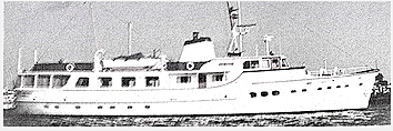
Blue Jacket
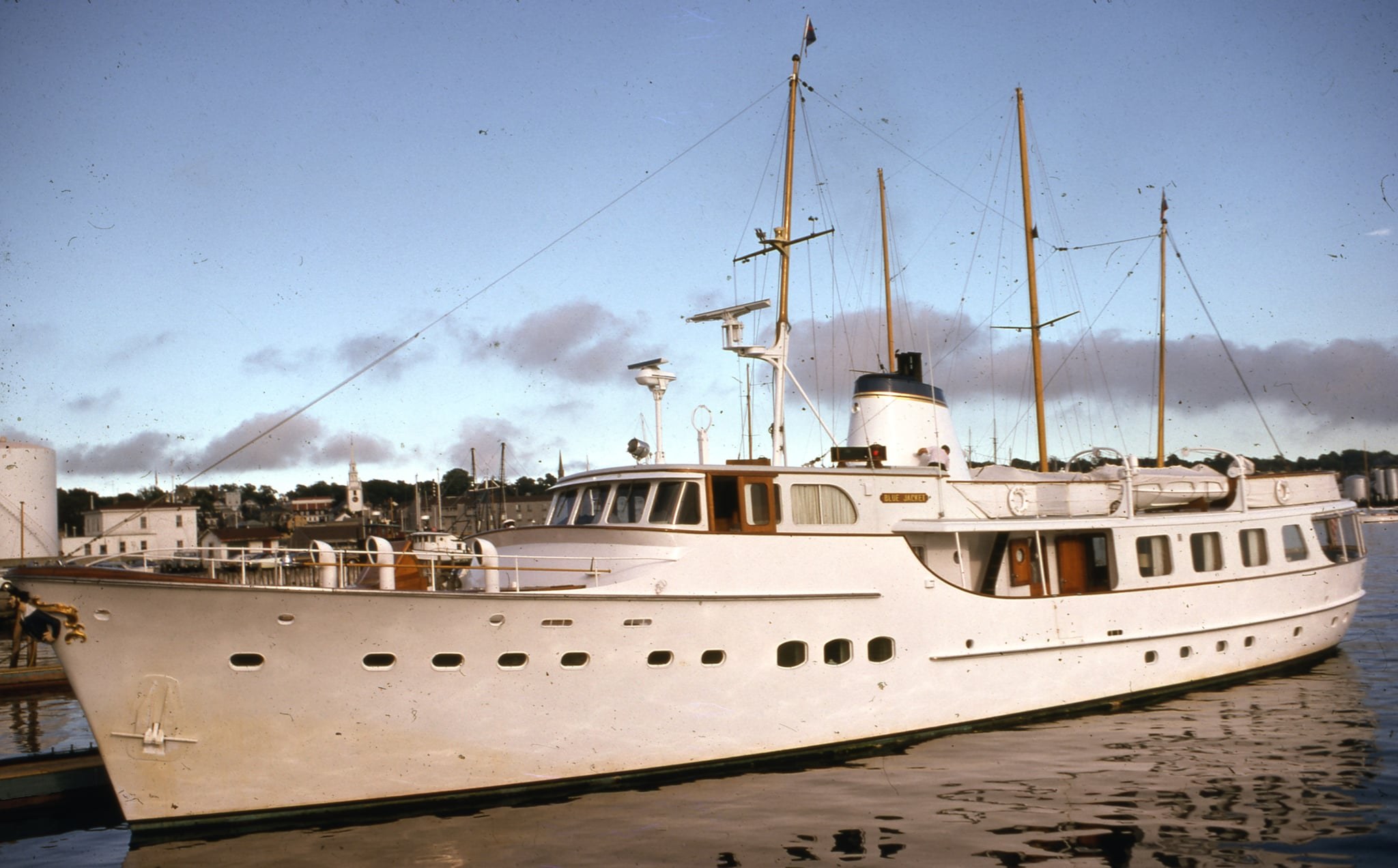
Blue Jacket was a 110' motor yacht, built in Netherlands by De Vries Lentsch and delivered in 1958 to businessman Henry D. Mercer. Her top speed was 13 kn and she boasted a maximum range of 1600 nm when navigating at cruising speed, with power coming from two Cummins diesel engines. She accommodated up to 6 guests in 3 staterooms, with 6 crew members waiting on their every need. She had a gross tonnage of 193 GT and a 21' beam, and she was built with a teak deck, a steel hull, and steel superstructure.
-- boatinternational.com
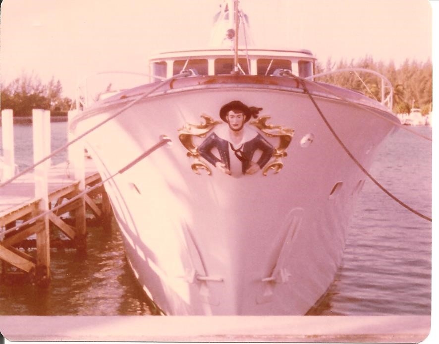
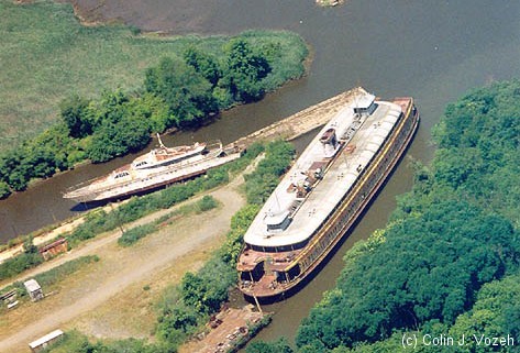
Google Earth shows the yacht was docked in the river in 1995. By 2002 it was wedged up the side creek. It looks very stuck at this point. In its current condition, it will have to be cut in pieces and trucked away. The Blue Jacket may no longer be leaking fuel and oil, but it still falls under the "Attractive Nuisance" doctrine.
the Shah of Iran's personal yacht
The old Staten Island ferry Mary Murray rotted on the Raritan River just east of the Turnpike bridge for many years before the state finally took an interest and forced the owners to clean up the site. I can't imagine that was not expensive. I'm sure the owners of the Blue Jacket are well aware of the story.
Needless to say, just stay away from places like this, and don't go climbing on private docks, trespassing sign or not. The nearby boat club is also private property.
Questions or Inquiries?
Just want to say Hello? Sign the .