Swimming River
- Navesink River - Claypit Creek ( 40.39367, -74.02062 )
- Navesink River - Fair Haven ( 40.36647, -74.04204 )
- Navesink River - Red Bank ( 40.35212, -74.06980 )
- Navesink River - Rumson (E) ( 40.37649, -73.99990 )
- Navesink River - Rumson (W) ( 40.37650, -74.01310 )
- Shadow Lake - Middletown ( 40.34698, -74.10476 )
- Swimming River - Middletown ( 40.34831, -74.08318 )
- Swimming River - Red Bank ( 40.33838, -74.08815 )
The Swimming River is an extension of the Navesink. On the map above, you can see the main put-in is at the upper-right in the new (2015) county park. You need to check in at the ranger's hut; there is a ramp fee of $7 per vessel, including kayaks and canoes. The park also has a strict closing time, at which the gates are locked. For details, see the county's page here:
- https://www.monmouthcountyparks.com/page.aspx?ID=4545
The concrete boat ramp is covered with a black slime that is the slipperiest stuff I have ever encountered. NASA should study this slime - it could be the next space-age lubricant. Don't use the ramp, use the little beach next to it, which is much safer. There are plenty of floating docks, but no floating kayak launch. Other facilities are limited to parking and porta-johns. The park is a vast improvement on the decrepit old boat yard that occupied that spot for decades.
From the county park you can go west up to the Swimming River Reservoir dam, a round trip of about 7 miles. The reservoir itself, which dates to 1901, is strictly off-limits, even to residents. Or you could go east under the bridges to the Navesink and Red Bank. The second marker to the south in Red Bank is unverified.
The river is very twisty, with high bluffs along the outside edges and marshes along the inside that often change sides. In many places the banks are armored with all manner of stone and concrete rubble. It quickly becomes monotonous. In places you can see erosion damage that probably dates to Sandy and Irene. There might be otters, otherwise wildlife was sparse, but is was November. In the upper stretches, there is road noise from the Parkway.
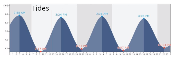
The water is brackish and black. At low tide I often found myself hitting the bottom, although I couldn't see it. I don't think this river is awfully polluted, just stagnant - the flow from the reservoir is not enough to flush it out. The current on this river is strictly tidal, and can be pretty strong, or negligible. That means that if you think you can fight your way upstream and get a free ride back, think again.
I wish I could recommend this spot, but I can't. There are better free alternatives nearby, like the spot on the Navesink in Red Bank that is literally five minutes away. Scroll the map a bit to the upper-right.
The county apparently runs a canoe/kayak rental here, but I have no details on it.

Questions or Inquiries?
Just want to say Hello? Sign the .