Recent Edits
- Aeromarine Industrial Park ( 40.44306, -74.18967 )
- Lake Lefferts - Matawan ( 40.41563, -74.23362 )
- Raritan Bay - Cliffwood (E) ( 40.45089, -74.22033 )
- Raritan Bay - Cliffwood (W) ( 40.45216, -74.22269 )
- Raritan Bay - Cliffwood (Whale Creek) ( 40.45090, -74.22274 )
- Raritan Bay - Keyport (E) ( 40.44095, -74.19534 )
- Raritan Bay - Keyport (W) ( 40.43921, -74.20160 )
- Raritan Bay - Laurence Harbor (E) ( 40.45877, -74.24622 )
- Raritan Bay - Laurence Harbor (W) ( 40.46223, -74.25482 )
- Raritan Bay - South Amboy (N) ( 40.48343, -74.27059 )
- Raritan Bay - South Amboy (S) ( 40.47946, -74.26831 )
- Raritan Bay - South Amboy Ramp ( 40.48401, -74.27416 )
- Raritan Bay - Union Beach (E) ( 40.44787, -74.16598 )
- Raritan Bay - Union Beach (W) ( 40.45479, -74.17517 )
- Superfund Site ( 40.45776, -74.24129 )
- Wagner's Marina - Matawan Creek ( 40.43540, -74.21416 )
The marker in the lower-center of the map is a super-easy put-in on Whale Creek, above. The other markers are a longer slog over the beach. All have convenient free parking (don't leave your vehicle in the launching area, that's a dick move!)
More: Cliffwood Beach - Aberdeen ...
- Liberty State Park - Jersey City ( 40.69768, -74.06520 )
Parking and launch access are free. There can be a good deal of boat traffic on the river, especially ferries, but if you are careful, you can paddle around the Statue of Liberty and Ellis Island.
More: Liberty State Park - Jersey City ...
- Aeromarine Industrial Park ( 40.44306, -74.18967 )
- Lake Lefferts - Matawan ( 40.41563, -74.23362 )
- Raritan Bay - Cliffwood (E) ( 40.45089, -74.22033 )
- Raritan Bay - Cliffwood (W) ( 40.45216, -74.22269 )
- Raritan Bay - Cliffwood (Whale Creek) ( 40.45090, -74.22274 )
- Raritan Bay - Keyport (E) ( 40.44095, -74.19534 )
- Raritan Bay - Keyport (W) ( 40.43921, -74.20160 )
- Raritan Bay - Laurence Harbor (E) ( 40.45877, -74.24622 )
- Raritan Bay - Laurence Harbor (W) ( 40.46223, -74.25482 )
- Raritan Bay - Union Beach (E) ( 40.44787, -74.16598 )
- Raritan Bay - Union Beach (W) ( 40.45479, -74.17517 )
- Superfund Site ( 40.45776, -74.24129 )
- Wagner's Marina - Matawan Creek ( 40.43540, -74.21416 )
This site varies, depending on when you go there. During the summer, and especially on weekends, there can be a lot of motorboats around. Other times, you can have the whole place to yourself.
More: Keyport / Matawan Creek ...
Kayaking is a pretty safe activity in New Jersey. There are no crocodiles or alligators this far north, and dangerous sharks are extremely uncommon. However, there are still a few things you should watch out for.
More: Wildlife Hazards ...
If you've never spent much time on the water, then you probably don't realize just how fast you can get sunburned. That is because you are getting a double dose of the sun - both direct and reflected off the water's surface. You can get burned very fast.
The best protection against the sun is a big broad-brimmed hat (not a baseball cap - that is nearly useless.) If you periodically dunk the hat in the water or wet it from a bottle, it will stay nice and cool.
More: Sunburn ...
This is for sit-on-top kayaks with closed hulls. Open-hull sit-inside kayaks don't really need hatches.
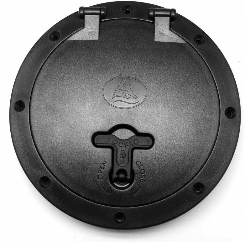
You can order any kind and size of hatch on eBay. They are easy to install - just trace the hole on the hull and cut it out with a jigsaw. A hatch like this one has a storage bag for small items like keys and phone, which removes for access to the inside of the hull.
More: Hatches & Storage ...
Here is a map you can use to see just water features. The level of detail increases as you zoom in. The boundary lines have been deleted, as they often follow and obscure water features. It is interesting to trace the rivers to their headwaters.
In the north, the state's two largest river systems are the Passaic and the Raritan, which intertwine. In the south, the Mullica forms a sizable river system. Only one river originates in New Jersey and leaves the state - the Walkill in the north. All others are captured by either the Delaware or the Hudson, or the extensive southern bays. The orange line is approximately the dividing line between east (Hudson/Atlantic) and west (Delaware River) drainages. The red line is the "fall line" - the boundary between the Piedmont uplands and Atlantic coastal plain. And that's your lesson in hydrology.
A weir or low-head dam is a barrier across the width of a river that alters the flow characteristics of water and usually results in a change in the height of the river level. Weirs are also used to control the flow of water for outlets of lakes, ponds, and reservoirs. There are many weir designs, but commonly water flows freely over the top of the weir crest before cascading down to a lower level.
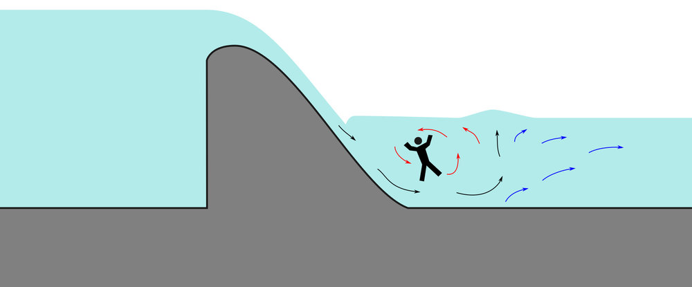
Even though the water around weirs can often appear relatively calm, they can be extremely dangerous places to boat, swim, or wade, as the circulation patterns on the downstream side - typically called a hydraulic jump - can submerge a person indefinitely. This phenomenon is so well known to canoeists, kayakers, and others who spend time on rivers that they even have a rueful name for weirs: "drowning machines".
More: Dams and Weirs ...
Amanda Oglesby
Asbury Park Press
June 19, 2026
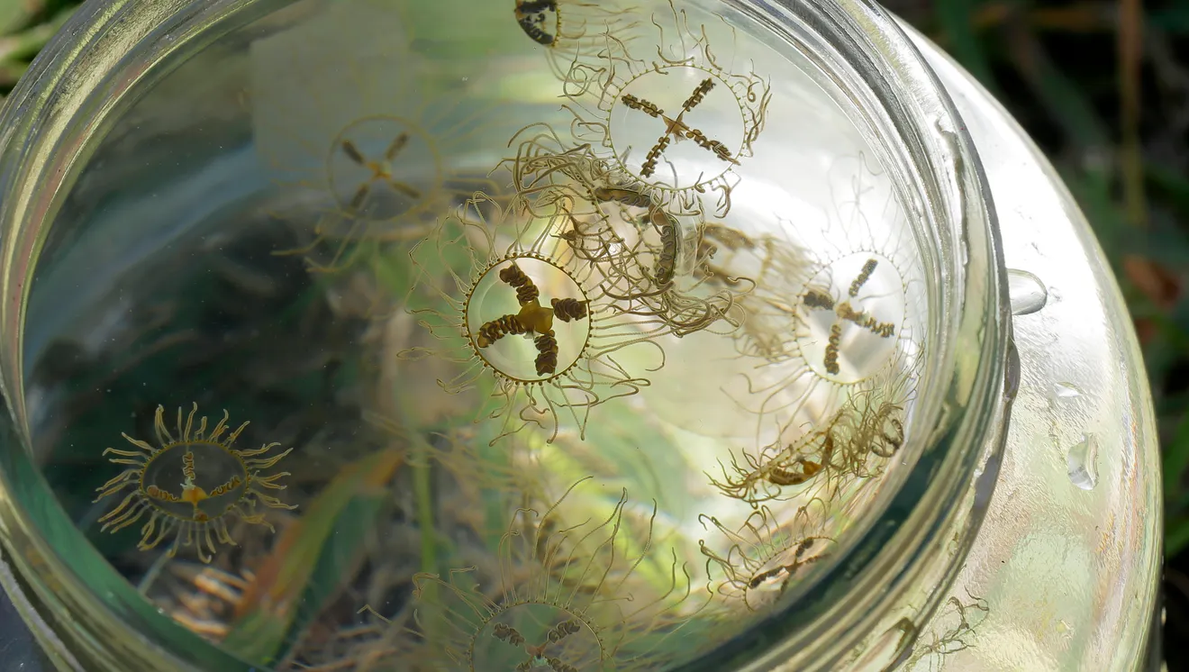
BRICK - A surge of clinging jellyfish are infiltrating the Metedeconk River, where a 6-year old child has already suffered a severe string, said New Jersey's leading expert on jellyfish.
Paul Bologna, the director of Montclair University's Marine Biology and Coastal Sciences Program, said the river's north bank has "a huge number of these clinging jellies." These coin-sized translucent jellyfish cling to sea lettuce and filamentous red algae common in the Jersey Shore's coastal rivers and estuaries, he said.
"Their tentacles have special adhesive pads that ... suction cup themselves onto that stuff," Bologna said.
Despite their small size, the clinging jellyfish pack a dangerously powerful sting, one that can lead to days-long hospitalizations, the biologist said.
More: Clinging jellyfish found in large numbers in Metedeconk River ...
- Delaware River Viaduct ( 40.93771, -75.10619 )
- Paulins Kill - access ( 41.07478, -74.78607 )
- Paulins Kill - Blairstown ( 40.97758, -74.94390 )
- Paulins Kill - Brugler Road ( 40.93581, -75.07082 )
- Paulins Kill - Columbia ( 40.92181, -75.08838 )
- Paulins Kill - Footbridge Park ( 40.98121, -74.95964 )
- Paulins Kill - Station Rd ( 40.94811, -75.06044 )
- Paulins Kill - Stillwater ( 41.03284, -74.87420 )
- Paulins Kill Lake - Newton ( 41.05273, -74.82674 )
- Paulinskill Viaduct ( 40.94795, -75.06134 )
More: Paulins Kill ...