Wildlife (2/4)

Kayaking is an outdoor activity. Yes, kids, you'll have to put down your game controllers and go outside. Out there is what us older folks call nature. Nature can actually be quite beautiful and interesting, and you don't have to worry about your screen resolution and refresh rate - both are infinity. So here is a short list of flora and fauna ( plants and animals ) that you might see in freshwater environments:

 1 2 3 4  

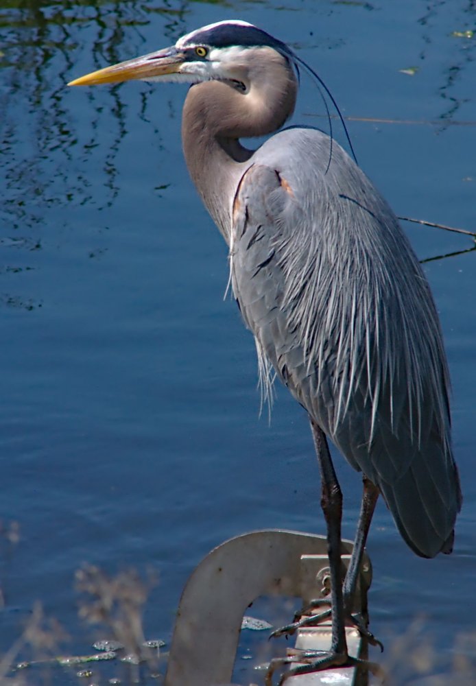
These are all long-legged, long-necked wading birds typically seen near the water's edge. They will tolerate your approach to a point, and then fly away - one of the advantages of being a bird.
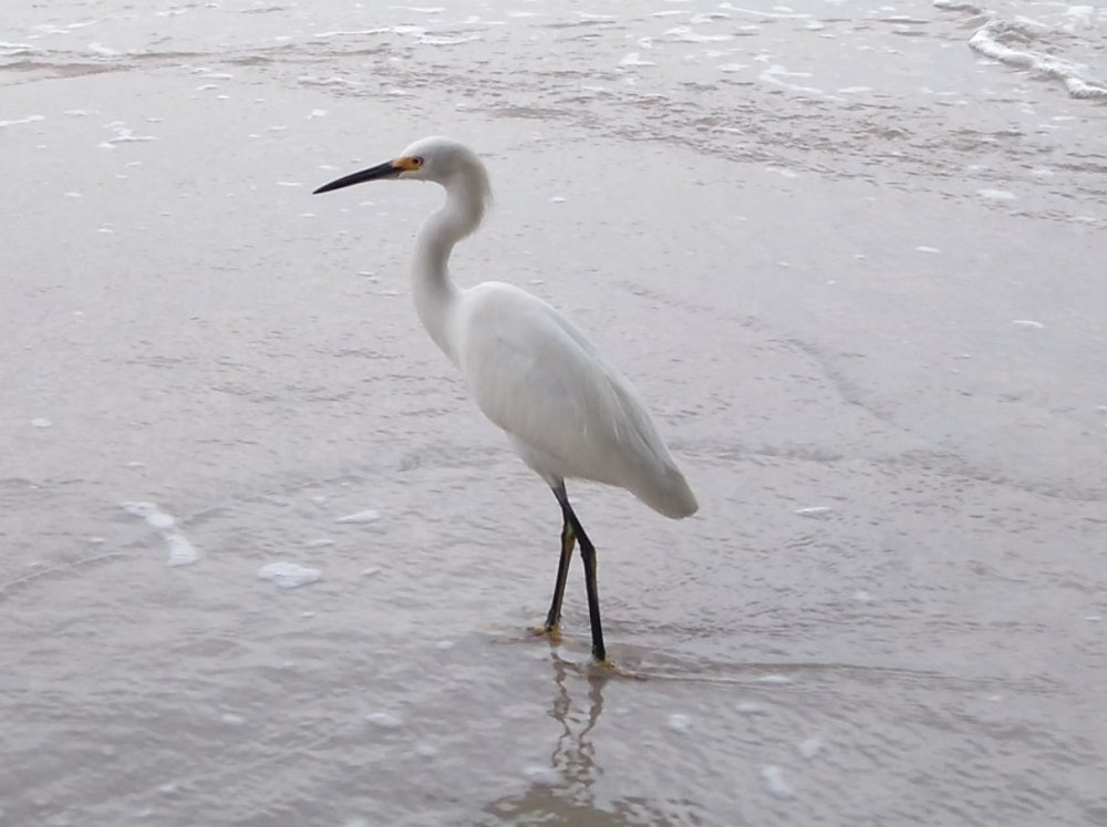
Snowy Egret

The Snowy Egret is very easy to spot, because it makes no attempt at camouflage, and stands out in any environment. They make up for this by being rather wary, although I have seen individuals beg for food from fishermen, a learned behavior that is not common. The Snowy Egret is very common; it would be difficult to go out kayaking and not spot at least one.


Fanwort

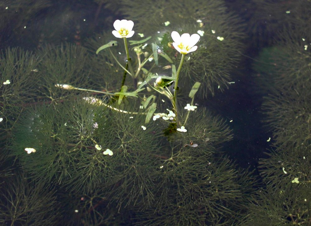
Fanwort is a fully aquatic true plant. It grows steadily through the warm months, and can choke-out large areas, then dies back in the winter. Fanwort produces tiny flowers above the surface.


Yellow Perch

American Bullfrog

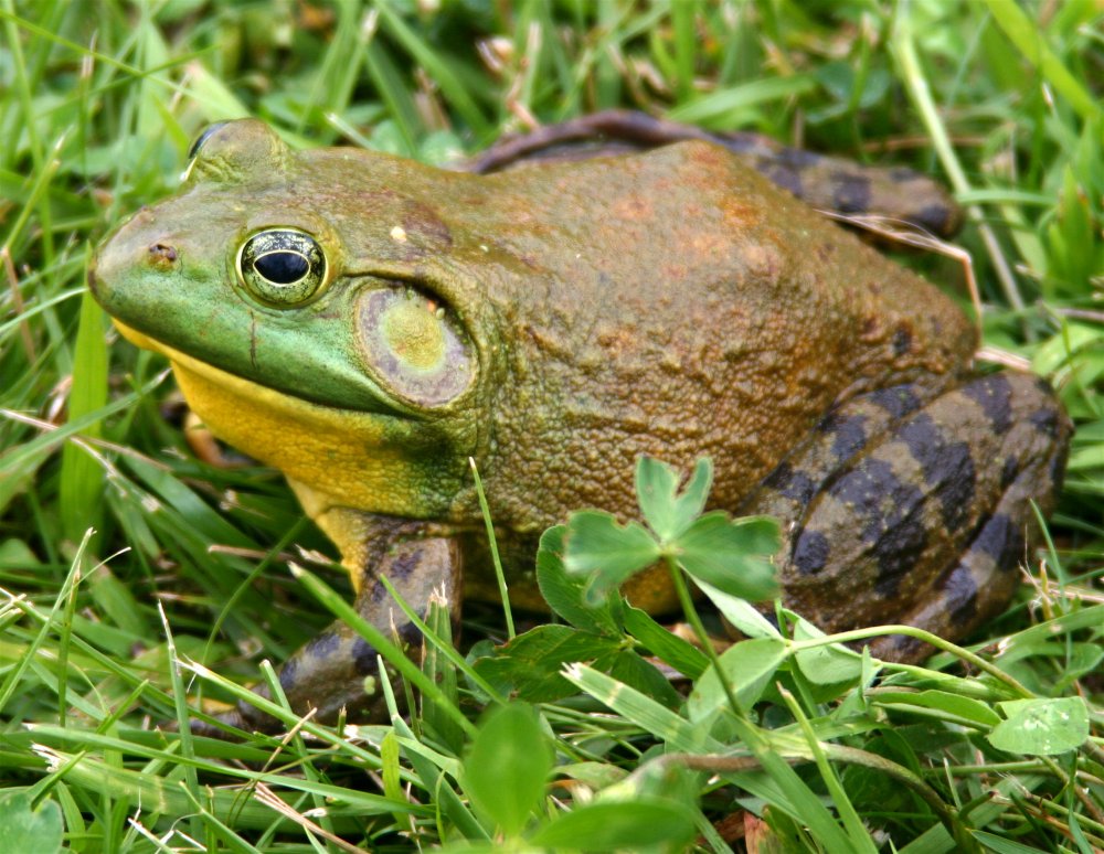
Frogs are seldom seen during the day, but easily discovered at night by their eye shine. In fact, it can be disturbing to see just how many of them there are around.


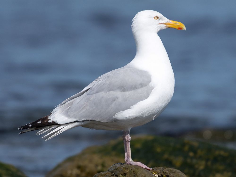
These birds are all associated with marine environments, but the truth is, they don't care. You'll find them wherever there is food. Since no place in New Jersey is really very far from the ocean, you can find most of these almost anywhere.

Herring Gull

Adult


Golden Shiner

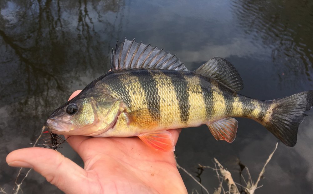
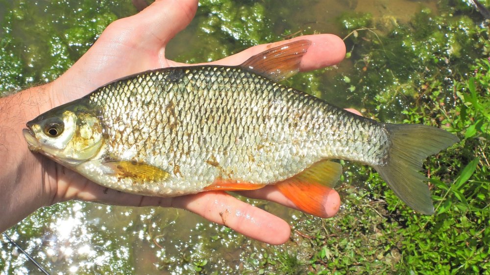
There are many different types of minnows in North America, but the one you are most likely to encounter kayaking is the Golden Shiner, and there is a good reason for this: If you are out after dark and you have a light, they will jump at it and can end up in the boat.


Muskrat

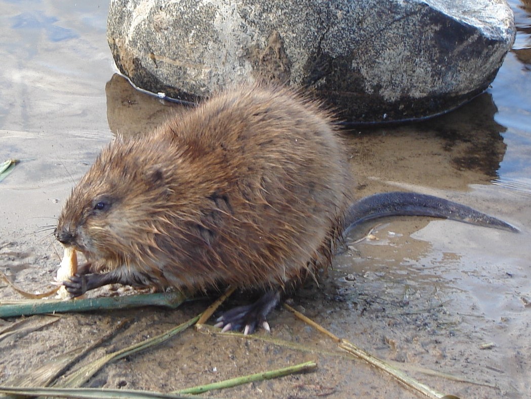
Muskrats are common across the state. While considerably bigger than plain old rats, they are nowhere near the size of beavers, which can get to 50 pounds. Muskrats have tails that are slightly flattened from side to side, unlike beavers which have broad flat tails. Both animals build conical houses in the water, but only beavers build dams.

-- Wikipedia


Osprey

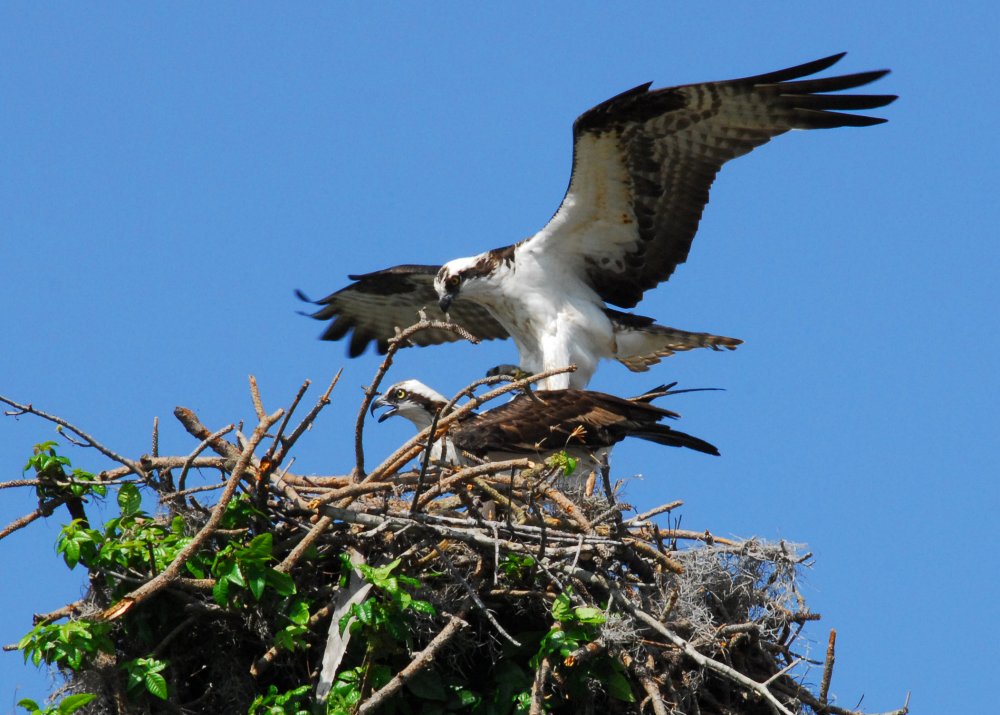
Osprey - note the under-wing patterning, see Bald Eagle below

Ospreys, or "Fish Hawks", are surprisingly common, and can be found just about anywhere. You'll typically see them flying high over the water from a tree on one side to a tree on the other, occasionally diving down on some unlucky fish. Ospreys are usually seen alone, but mating pairs stay together, and I think young siblings stay together for a while as well. Ospreys are one of the biggest birds that you are likely to see. A single species has an almost worldwide distribution - pretty much everywhere except Australia.


River Otter

Otters are aquatic weasels. You may find them climbing around on banks, or splashing around in the water, especially around dusk.


Wildlife

 1 2 3 4  

Ocean County
( 39.82966, -74.22671 )

  1. Bamber Lake - Lacey ( 39.89577, -74.31959 )
  2. Barnegat Bay - Barnegat ( 39.75401, -74.20171 )
  3. Barnegat Bay - Barnegat Light (N) ( 39.75763, -74.11138 )
  4. Barnegat Bay - Barnegat Light (S) ( 39.74500, -74.11764 )
  5. Barnegat Bay - Bay Harbor Park ( 40.01977, -74.12731 )
  6. Barnegat Bay - Beach Haven ( 39.57015, -74.23933 )
  7. Barnegat Bay - Brant Beach ( 39.61673, -74.20110 )
  8. Barnegat Bay - Bridge to Nowhere ( 39.68394, -74.20766 )
  9. Barnegat Bay - Great Bay Blvd ( 39.56316, -74.34202 )
  10. Barnegat Bay - Harvey Cedars ( 39.70465, -74.13703 )
  11. Barnegat Bay - Island Beach SP ( 39.85222, -74.08899 )
  12. Barnegat Bay - Lavallette ( 39.96933, -74.07421 )
  13. Barnegat Bay - Little Egg Harbor ( 39.53556, -74.26441 )
  14. Barnegat Bay - Mantoloking Bridge ( 40.04124, -74.05880 )
  15. Barnegat Bay - Oyster Creek ( 39.80873, -74.18455 )
  16. Barnegat Bay - Parkertown ( 39.60978, -74.29231 )
  17. Barnegat Bay - Seaside Heights ( 39.94524, -74.07956 )
  18. Barnegat Bay - Sedge Island ( 39.80786, -74.09599 )
  19. Barnegat Bay - Ship Bottom ( 39.65232, -74.18484 )
  20. Barnegat Bay - Surf City ( 39.65966, -74.17848 )
  21. Barnegat Bay - Tilton Point ( 39.96900, -74.11284 )
  22. Barnegat Bay - Tuckerton ( 39.57671, -74.33078 )
  23. Barnegat Bay - West Creek ( 39.63100, -74.29618 )
  24. Barnegat Bay - Woodville ( 39.98917, -74.13476 )
  25. Bass River - New Gretna ( 39.57721, -74.45079 )
  26. Batsto River - Wharton State Forest ( 39.71014, -74.66747 )
  27. Bay Parkway - Lacey ( 39.80572, -74.17212 )
  28. Bunker Hill Bogs - Jackson ( 40.08255, -74.29256 )
  29. Cedar Creek - Berkeley ( 39.90248, -74.24513 )
  30. Cedar Creek - Double Trouble ( 39.89402, -74.22495 )
  31. Cedar Creek - Lanoka Harbor ( 39.86936, -74.17065 )
  32. Cedar Run - Stafford ( 39.64365, -74.24592 )
  33. Chip's Folly Campground ( 39.63281, -74.49799 )
  34. Collier's Lake - New Egypt ( 40.06799, -74.44856 )
  35. Country Lake - Pemberton ( 39.94530, -74.54257 )
  36. Crosswick's Creek - New Egypt (N) ( 40.08505, -74.54006 )
  37. Crosswick's Creek - New Egypt (S) ( 40.06679, -74.53226 )
  38. Deer Head Lake ( 39.85043, -74.21101 )
  39. Forge Pond - Brick ( 40.06646, -74.13446 )
  40. Great Bay - Graveling Point ( 39.53949, -74.38761 )
  41. Great Bay - Great Bay Blvd ( 39.52160, -74.31849 )
  42. Great Bay - Great Bay Blvd (end) ( 39.50902, -74.32008 )
  43. Great Bay - Motts Creek ( 39.51826, -74.43637 )
  44. Great Bay - Rand's Marina ( 39.53934, -74.32614 )
  45. Harry Wright Lake ( 39.93076, -74.35880 )
  46. Holiday Lake - Barnegat ( 39.73882, -74.26470 )
  47. Horicon Lake - Lakehurst ( 40.00720, -74.32177 )
  48. Island Beach SP Marina ( 39.90606, -74.08713 )
  49. Lake Absegami - Bass River ( 39.62529, -74.42760 )
  50. Lake Barnegat ( 39.84169, -74.20078 )
  51. Lake Carasaljo - Lakewood ( 40.09304, -74.22817 )
  52. Lake Riviera - Brick ( 40.04590, -74.14573 )
  53. Lake Shenandoah - Lakewood ( 40.08845, -74.19941 )
  54. Lake Success - Jackson ( 40.05785, -74.39243 )
  55. Lebanon Lake - Pemberton ( 39.90686, -74.56550 )
  56. Little Pine Lake - Pemberton ( 39.98857, -74.57096 )
  57. Manahawkin Lake - Stafford ( 39.69641, -74.26116 )
  58. Manasquan Reservoir - Howell ( 40.17217, -74.20300 )
  59. Manasquan River - Allaire ( 40.14376, -74.11673 )
  60. Manasquan River - Beverly Beach ( 40.10498, -74.09649 )
  61. Manasquan River - Brice Park ( 40.13764, -74.11038 )
  62. Manasquan River - Dog Beach ( 40.10623, -74.03785 )
  63. Manasquan River - Glimmer Glass ( 40.11653, -74.04946 )
  64. Manasquan River - Howell ( 40.17519, -74.16981 )
  65. Manasquan River - Ramshorn Drive ( 40.11961, -74.09418 )
  66. Manasquan River - Riverfront Park ( 40.08835, -74.07142 )
  67. Manasquan River - RR Bridge ( 40.10052, -74.04905 )
  68. Manasquan River - WMA ( 40.13689, -74.10431 )
  69. Metedeconk River - Bay Ave ( 40.06602, -74.05130 )
  70. Metedeconk River - Bay Blvd ( 40.06288, -74.05502 )
  71. Metedeconk River - Bennett's Pond ( 40.13058, -74.28406 )
  72. Metedeconk River - Brick ( 40.05687, -74.11203 )
  73. Metedeconk River - Dock Rd ( 40.05055, -74.11413 )
  74. Metedeconk River - Sandy Point ( 40.05129, -74.07785 )
  75. Mirror Lake - Pemberton (N) ( 39.97209, -74.56941 )
  76. Mirror Lake - Pemberton (S) ( 39.96729, -74.57847 )
  77. Mullica River - Hay Road Beach ( 39.57349, -74.53943 )
  78. Oswego Lake - Penn State Forest ( 39.73454, -74.49111 )
  79. Oswego River - Martha Bridge ( 39.68159, -74.51416 )
  80. Oyster Creek ( 39.80866, -74.18460 )
  81. Pine Lake ( 40.00910, -74.24948 )
  82. Presidential Lakes - Pemberton ( 39.91110, -74.57680 )
  83. Prospertown Lake - Jackson ( 40.13497, -74.45779 )
  84. Rancocas Creek - New Lisbon ( 39.96205, -74.64102 )
  85. Rancocas Creek - Pemberton (E) ( 39.96746, -74.58789 )
  86. Rancocas Creek - Pemberton Heights ( 39.96244, -74.65567 )
  87. Stafford Forge WMA - Manahawkin ( 39.66881, -74.32090 )
  88. Stockton Lake - Manasquan ( 40.11739, -74.03460 )
  89. Sunken Branch - Toms River ( 39.96792, -74.24211 )
  90. Toms River - Beachwood ( 39.94250, -74.18446 )
  91. Toms River - Cranmoor Manor ( 39.94859, -74.16332 )
  92. Toms River - Gilford Park ( 39.94262, -74.13393 )
  93. Toms River - Huddy Park ( 39.95082, -74.19782 )
  94. Toms River - Oceangate Beach ( 39.92840, -74.13547 )
  95. Toms River - Pine Beach ( 39.93789, -74.15776 )
  96. Toms River - Pine Lake Park ( 40.00353, -74.24106 )
  97. Toms River - Pocket Park ( 39.94102, -74.17354 )
  98. Toms River - Rt 527 ( 39.98639, -74.22380 )
  99. Toms River - Water St ( 39.95171, -74.19990 )
  100. Toms River - Winding River Park (N) ( 39.98350, -74.22255 )
  101. Toms River - Winding River Park (S) ( 39.96802, -74.21393 )
  102. Toms River - Windsor Park ( 39.94676, -74.15658 )
  103. Turn Mill Pond - New Egypt ( 40.06371, -74.44772 )
  104. Twilight Lake - Bay Head ( 40.07474, -74.04404 )
  105. Wading River - Beaver Branch ( 39.65059, -74.51890 )
  106. Wading River - Bodine Field Road ( 39.65401, -74.52497 )
  107. Wading River - Evans Bridge ( 39.67517, -74.54066 )
  108. Wading River - Godfrey Bridge ( 39.68987, -74.54612 )
  109. Wading River - Harrisville Pond ( 39.66547, -74.52434 )
  110. Wading River - Hawkins Bridge ( 39.71442, -74.56595 )
  111. Wells Mills Pond ( 39.79387, -74.27701 )
  112. Whitesbog - Pemberton ( 39.96504, -74.48711 )
  113. Wreck Pond - Sea Girt ( 40.13880, -74.02726 )
  114. Wreck Pond - Spring Lake ( 40.14107, -74.04003 )